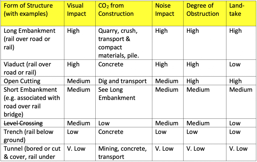
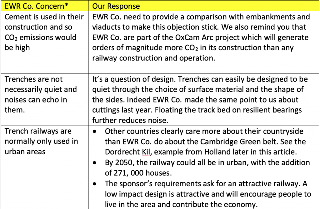
“[EWR Co.’s] drive to put Community Right at the Heart of the new East West Rail Connection” Source: EWR Co. Community Hub – Why Would our Community be Worried About That?
During the 2021 consultation, Cambridge Approaches requested some more information from EWR Co. to inform our response. Despite considerable efforts from EWR Co. and ourselves, previous experience with trying to get useful answers from EWR Co. led us to try instead getting legal help from lawyers Leigh Day in drafting the key information requests. Around the time that the consultation closed, all our requests were refused. EWR Co. said that the requests were “vexatious” and “manifestly unreasonable” and that the public interest lay in refusal. They reached this conclusion not just by reviewing the actual requests, but looking at the correspondence that they had received from Cambridge Approaches and anybody they judged might have been in contact with us over the previous year or so. They also looked at minutes of parish council meetings discussing the EWR. It seemed anything but focussing on the information we had actually asked for. We appealed the decision after the consultation had closed because we felt that this information was still important and to give EWR Co. a chance to review their decision when they were not in the middle of the consultation. Unfortunately, their internal review response was very similar to the first one. We have referred the matter to the Information Commissioner’s Office who have undertaken to review it. There is six month long queue at the ICO. Sadly it seems our experience with this process is not unusual.
I have copied the information that we requested in the letter drafted by Leigh Day below. What do you think? Are they manifestly unreasonable? Are they vexatious? Or were we just trying to understand the underlying information behind the options they had considered for the railway’s approach to Cambridge? I was there and can tell you that our intention was the latter. On our side we hope to resume a more constructive dialog with EWR Co.
Our Outstanding Requests for Information from May 2021
Request 1: EWR is asked to provide the information constituting the “high-level environmental appraisal” of the nine Route Alignment Options and the proposed northern approach
Request 2: Insofar as it is not covered by request 1, EWR is asked to provide the information upon which it relies in concluding that it is “confident” that the detailed design can mitigate any impacts on the Wimpole and Eversden Woods SAC. Such information is to include the impacts identified and the mitigations considered.
Request 3: EWR is asked to provide the information constituting the “operational analysis” on which it relies in concluding that the northern approach proposed in appendix F of the Second Consultation Document would require the provision of a four-track railway in section NA2.
Request 4: EWR is asked to provide the information upon which it relies in concluding that the Shepreth Branch Royston Line could remain as a twin track railway from the new Hauxton Junction to the Shepreth Branch Junction.
Request 5: EWR is asked to provide the information on which it relies in concluding that no “significant alterations” will be needed to the bridge where the Shepreth Branch Royston Line crosses under the A1301. Such information is to extend (insofar as it has been considered) to both a two and four-track approach to the Shepreth Branch Line and to the grade-separated junction that EWR considers may be needed at Shepreth Branch Junction
Request 6: EWR is asked to provide the information it holds in respect of any assessment of the number of properties that would need to be demolished if the portion of the Shepreth Branch Royston Line from the Hauxton Junction to the Shepreth Branch Junction were to require works to increase the number of tracks
Request 7: EWR is asked to provide any non-public information provided to it by Network Rail or other organisations, or any assessment it has itself undertaken, which leads to the conclusion that there may be demand by 2043/2044 for around 24 freight trains per day on the line between Bedford and Cambridge. Such information is to include any quantification of the current freight use of the Shepreth Branch Royston Line and the West Anglia Main Line.
Request 8: EWR is asked to explain the need in principle for the viaducts, cuttings, and embankments between Cambourne and Hauxton Junction on the southern approach
Request 9: EWR is asked to provide any engineering long section drawings which it has produced to assess the northern approach. If no such drawings exist, EWR is asked to provide (a) the length of viaduct; (b) length in cutting; and, (c) length on embankment of its proposed northern approach.
Request 10: Insofar as EWR has already undertaken this assessment, EWR is asked to provide a list of the roads which will be permanently severed or otherwise obstructed by each of the Route Alignment Options comprised in the southern approach (Cambourne through to Cambridge station)
Request 11: EWR is asked to provide the information constituting the updated “cost estimates” provided by Network Rail and Atkins referred to in the Second Consultation Technical Report at 5.4.12, and any such cost estimates produced subsequent to those referred to in that paragraph. Such estimates are not to be limited to the figures, and should (insofar as they exist) include the explanation of the estimates provided by Network Rail and Atkins
I am writing to you instead of Simon Blanchflower as I understand that he is retiring from his position at EWR Co.
Can you confirm that work on the central section (CS) of the East West Railway has now been suspended?
I ask because there are many people living on or near the preferred route that are now in a state of limbo, which they fear will drag on for years as dates in the planning process seem to be slipping and slipping. We need to be able to get on with our lives. Cambridgeshire County Council asked the Department for Transport a similar question after the Autumn Spending Review and as of this month have received no reply.
As you know the estimated cost of the preferred route in your words “matured” during 2019 as a result of more accurate work from Faithful and Gould. This resulted in a 3x cost increase for the preferred route area from January 2019 to January 2020. The benefit to cost ratio of the central section published in January 2020 was low and the following things have happened since:
Commitment to the EWR CS was conspicuous by its absence from the 2021 autumn spending review (SR21) which covers the next few years. In contrast, the work on the A428 was explicitly mentioned. This was flagged as a problem by the EWR ML partnership and the EEH both before and after SR21.
Significant additional work was identified in 4-tracking into Cambridge on the southern approach, together with 6-tracking and housing demolition in Bedford in the 2021 consultation document and no revised costing was published.
Considerable local opposition to the emerging preferred route has been expressed all along the route from Bedford through St. Neots to Cambridge – the petition for a proper consultation on a northern approach to Cambridge stands at over 12,000.
The wider benefits of the land value increase around new EWR CS stations due to the OxCam Arc look like they will not occur due to the shift in focus of the government to levelling up outside of London and the South East. This was confirmed by Mr. Gove on the Radio 4 Today Programme on the 10th January 2022. When asked about the much-delayed levelling up white paper, he said that the decision had been made at the time of the spending review and that the aim was to “get every part of the UK operating at the level that London and the South East currently do”. He also mentioned a preference for housing on brown field sites – hardly consistent with some of the new EWR station locations. Where does that leave the OxCam Arc upon which the yet-to-be-published EWR CS business case apparently depends? I note that the leader of the OxCam Arc team in Whitehall, Kris Krasnowski was redeployed to the Scottish Office in July 2021.
Local housing plans such as the one in Greater Cambridge have taken no account of the EWR CS station locations.
Passenger rail numbers continue to be depressed and there are continued signs of a permanent shift in behaviour after the pandemic to more home working. There are press reports of plans to lay off rail staff in their thousands.
No one has demonstrated that freight traffic on the central section will move the needle on the business case for the CS. However, freight, especially on elevated track continues to cause great anxiety for people living near the emerging preferred route, both near the proposed great embankments and viaducts and in the city and town centres. The emerging preferred route is really not great for freight.
Perhaps at the insistence of past members of central government, EWR Co. continue to emphasize the importance of rapid transit from Oxford to Cambridge even though common sense and I believe your own forecasts say that most of the passenger traffic will be local. As a result, the business case for a more local railway may be more favourable.
These considerations fuel my concern that you will not find a good business case for the central section. I look forward to your answer to my question in bold at the start of this letter.
If you want to make your voice heard about the OxCam Arc (of which EWR is a part) one thing you can do is to have a look at the 5 minute questionnaire put together by a group called StopTheArc – it asks some of the fundamental questions not in the official MHCLG consultation. They were kind enough to ask Cambridge Approaches to review it before publishing.
Still No Published Business Case
One of the things we do on this Cambridge Approaches blog is to ask questions about the business case for the central section of the EWR.
We know from EWR Co.’s Preferred Route Option Report published in January 2020 that the estimated total cost was £5.6Bn (having risen from £1.9Bn a year earlier) and, since we understand that this will be funded by the taxpayer, it’s not unreasonable for us to ask for the business case. For comparison, would the EWR Co. management team get very far in raising £5.6Bn on Dragon’s Den if, after working on their project since 2018, they still won’t share a business case with the people that they want to fund it? Put another way, they are taking us for granted.
For the record, the public line on the lack of business case from EWR Co. in response to our Freedom of Information request at the start of 2021, was that public servants need a safe space and that it is not normal for a business case to be published at this stage. People are sufficiently disturbed by the proposals so that they received 190,000 responses to the 2021 consultation, but it’s too early to publish the case for the project. Really?
This questioning of the business case was followed by Anthony Browne MP asking about the effect of COVID on travel patterns which will likely permanently reduce passenger numbers by 40% as people have learnt to work from home. EWR Co.’s recent video from EWR Co on the 23rd August 2021 talks about this problem (see 3:07 into the video) without any convincing resolution. Covid-19 will pass, but the technology that allows people to work from home is here to stay and employee expectations have now changed.
As EWR Co point out (video 2:36), the hope is that people will move into the area to live and work and set up businesses so it might be that this influx of people will to some extent counteract the others working from home. Indeed, the NIC report “Partnering for Prosperity” set out a target of 1.1 million additional jobs in the area by 2050 corresponding to about 2 million more people and 1 million more homes. We assume that the focus of this growth is intended to be along the EWR around the initial stations and any new ones that are added over the lifetime of the railway. (If not what is the point of the railway exactly?) The impact of this on existing residents will be higher than that of the railway alone.
The second EWR consultation ended in June 2021 and we still have a lot of unanswered questions. Looking at the consultation responses from bodies like the South Cambridgeshire District Council and the Cambridgeshire County Council, we were not the only ones with outstanding questions. You can read the Cambridge Approaches consultation response here and some others here.
In the Cambridgeshire County Council 2021 EWR consultation response we find the following:
Growth: The East West Rail Central Section should support growth and enable sustainable transport patterns to be realised from that growth. The detailed alignment of the Central Section should be considered alongside the consideration of appropriate locations for growth in the Ox-Cam Arc, and the appropriate scale of that growth. The strategy for station provision on the Central Section must be informed by the consideration of appropriate locations for growth.
This is an appeal for the route alignment of the EWR central section and its station locations to follow a co-ordinated housing plan.
South Cambridgeshire District Councils 2021 EWR consultation response says:
Significant further work is still needed to understand the localised impacts of the scheme, the options for mitigation, their effectiveness and implementation including the sequencing with wider strategic infrastructure and development.
Again, they are concerned that the railway is not aligned with the housing and economic plan for the area.
So, some of the outstanding questions centre on how the route relates to other plans for the area e.g. for economic growth, housing and local transport. Unfortunately for all concerned, the EWR Co. management team are not in a good place to answer these questions because they are being pushed by the Department for Transport to get the route defined in advance of key decisions by other bodies. This heightens the risk that EWR will not choose the right approach which will be to the detriment of its business case, local residents and potential users of the service.
Train Wreck in St. Neots
EWR Co.‘s Simon Blanchflower post consultation press release celebrated the scale of response:
The number of responses we’ve received, the breadth of information and level of detail they contain demonstrates the value of consulting with local people at an early stage, and the huge level of public interest in East West Rail.
But a strong response should not be taken as meaning respondents are in favour of what is being proposed.
We are surprised that EWR has aligned its preferred routes in close proximity to one of the largest housing developments in the East of England. None of the five corridors considered in the first phase of the consultation included this land, and the late inclusion has come as a shock to residents, housing developers and St Neots Town Council.
St Neots Town Council is opposed to the construction of these viaducts and asks EWR to urgently reconsider plans to align these routes with the eastern edge of our town.
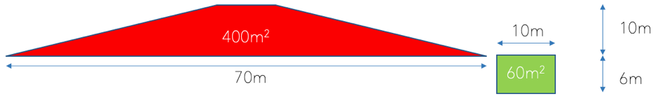
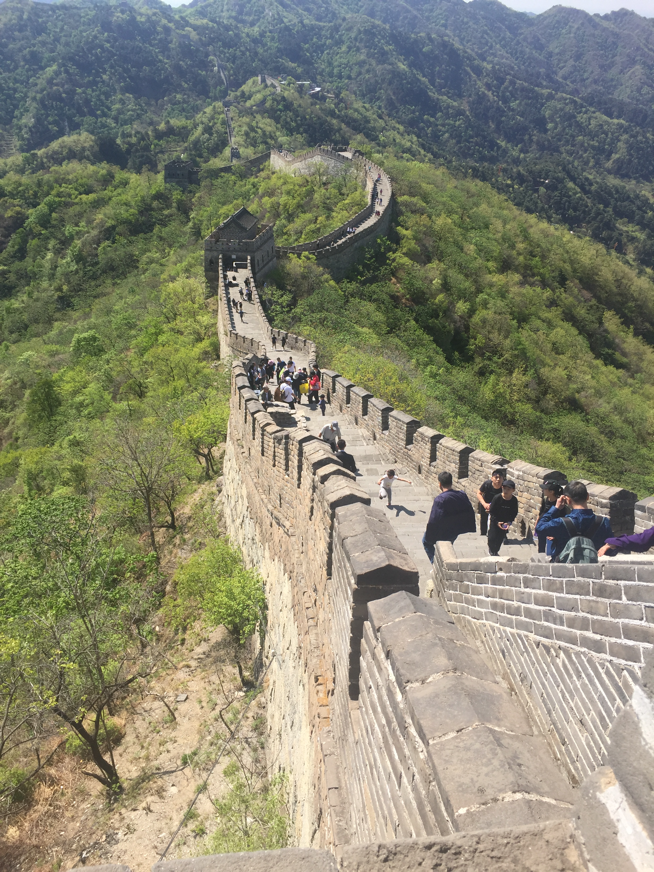
EWR are proposing 12m high viaducts through St. Neots East reminiscent of the Great Wall they have proposed between Cambourne and Hauxton. There is also no station at St. Neots, maybe that is because of the Tempsford development, but since we don’t even have a vision for the OxCam Arc Spatial framework who knows? More to the point how do EWR Co. know?
Greater Cambridge Shared Planning (GCSP) Local Plan
On the 31st August 2021 an update to the local plan was published. It is currently under consideration by councillors and will not open to public consultation until later in the year (November?). The updated plan will run to 2041 (previously it ran from 2011-2031).
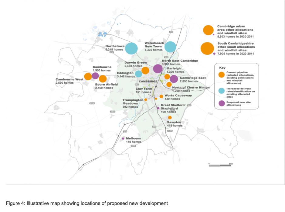
Figure 1 shows an overview map of the developments proposed.
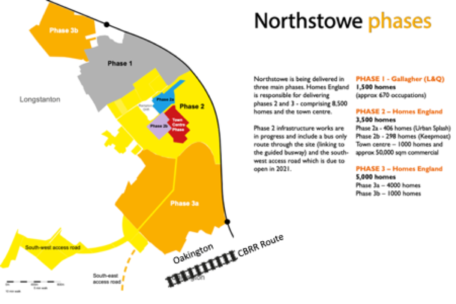
Note that no new housing development is proposed around Cambridge South Station, despite this being one of the repeated justifications for the southern approach to Cambridge for the EWR. This diminishes both the justification for the EWR southern approach route and the business case for the central section of the railway. In contrast, significant new development around the northern route proposed by CBRR is confirmed and developments in Northstowe and Waterbeach are to be accelerated together with new brown field developments to the north and east of Cambridge.
The Mythical Houses Around Cambridge South Station
The myth of significant housing growth around Cambridge South Station has been discussed in a recent letter from a local resident to local District Councillors as follows:
“…the county council’s 2019 response to EWR Co (repeated in the third bullet of paragraph 2.3 of the covering note to the draft response) said ” The ability of EWR services to … provide for the very significant planned economic and housing growth in the south of the city including at the Cambridge Biomedical Campus”. This was an odd statement in 2019, given that the county council is not the planning authority, and it was, at the time, not evident from the Local Plan what housing development the county council had in mind in saying this. It appears even odder now, given the variety of housing development options under consideration by Greater Cambridge Shared Planning (“GCSP”) – see their November 2020 development strategy options assessments and the emergence of the North East Cambridge Action Plan.
In 2019, the constituent authorities of what is now GCSP made clear a new local plan was coming and that they would be looking at all reasonable development strategies and SCDC at least has repeated this point in its response to this consultation. Notwithstanding this, what the county council said in 2019 appears to be understood as fact not just by EWR Co, but also by EWR Consortium.
Among the papers for the EWR Consortium 9 June meeting (not, in fact, discussed) is this one under the heading “realising the potential of EWR” which says (emphasis added):
Cambridge South: Cambridge South [station] will be located near to Addenbrooke’s Hospital and Cambridge Biomedical Campus – key employersand site for new homes in the south of Cambridge.Planned to open in 2025, the station will be on the Cambridge line and West Anglia Main Line, and should also sit on the East West Main Line once it opens a few years later.”
It goes on to say that “The Cambridgeshire and Peterborough Combined Authority is working on the Outline Business Case…”. It is not entirely clear what this outline business case is for and could be a historic priority of the former Mayor because the next paragraph of the document mentions the CAM.
It is possible that all these statements can be traced back to what the county council said in its 2019 response which may have served to lead others to believe that there were likely developments in the south of Cambridge. It seems important for both EWR Co and EWR Consortium to understand the true position and the county council should take responsibility for doing this.”
Now would be a good time for EWR Co and EWR Consortium to review the evidence for the southern approach and the whole business case in the light of this new local plan since the local authorities are planning no new houses around either EWR station on the southern approach in Cambridgeshire all the way out to 2041. Do MHCLG people know better that the local experts about how best to develop Cambridge?
Conflicting Plans at Highfields Caldecote
One of the consequences of the EWR route being fixed in advance of related housing plans are conflicts emerging when the housing plans do come out. The detailed costing information that came out with the last consultation indicates that the preferred route had been established in outline all the way back in mid-2019. Such conflicts can no doubt be resolved by adjustments to the railway route or knocking down houses, but they are also symptomatic of the lack of co-ordination between EWR Co. and the other planning authorities.
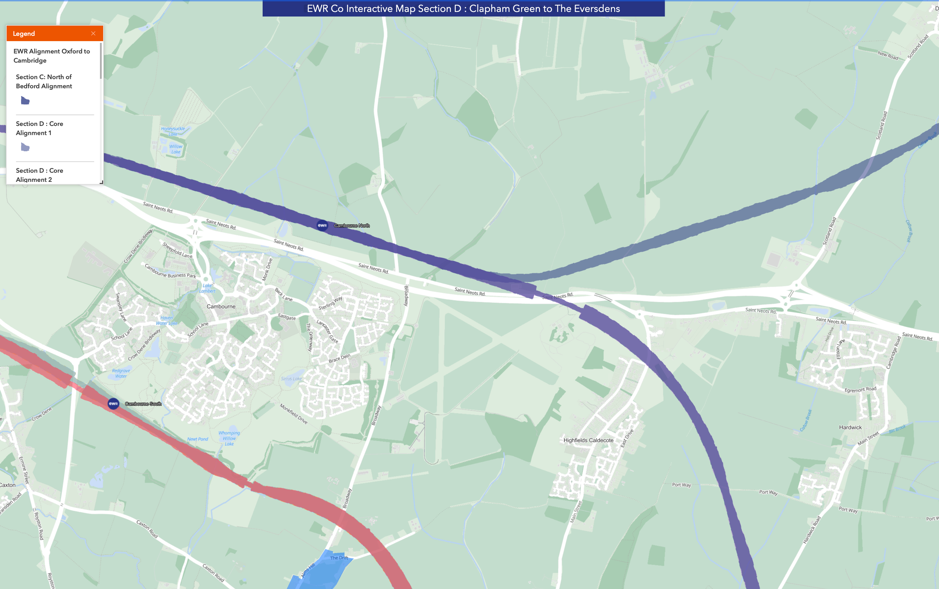
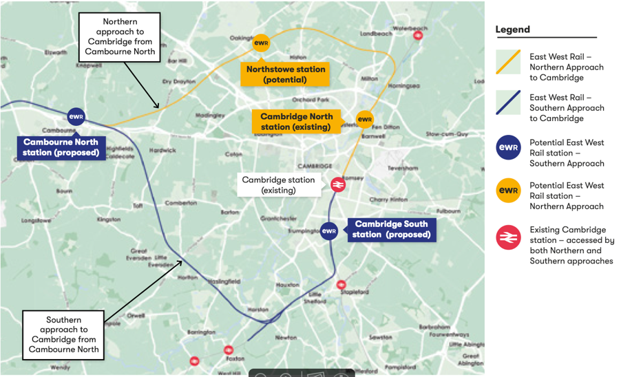
Here is another example of the issue. EWR Co’s preferred route goes through a station north of Cambourne and crosses the A428 with a long, skewed bridge just north of Highfields Caldecote (see blue route in Figure 2).
Figure 2 EWR Co Preferred Route Crossing the A428
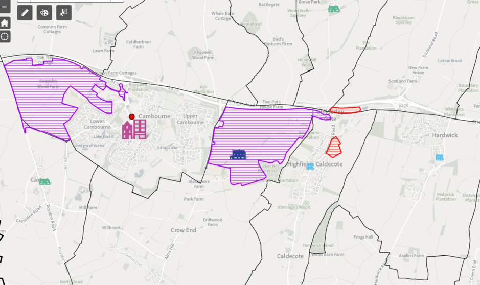
However, the updated local plan has housing across the proposed route of the railway (See Figure 3).
Figure 3 GCSP Local Plan for the Same Area
Rate of Housing growth
The GCSP planners are estimating that to meet the demands of the local economy (i.e. the number of new jobs they foresee over the period) we need to add 1,771 houses per year over the next 20 years leading to a total of 48,794 houses from 2011 to 2041. This is a lot less than the 271,000 houses in the National Infrastructure Commission report (NIC Report) for this end of the EWR central section up to 2050.
It has been acknowledged that the case for the EWR central section depends on housing growth. For example, this is stated in the recent EWR video referred to earlier. In fact, it depends on the transformational housing growth put forward by the NIC report. However, if this level of growth is not going to come from the local plan where could it come from?
OxCam Arc Consultation
The Ministry of Housing Communities and Local Government (MHCLG) recently launched a consultation to help them shape the vision for the OxCam Arc. In section 5.8 of this document there is a rather hard-hitting paragraph:
“5.8 In parallel to the development of the Spatial Framework, the government is also exploring options to speed up new housing and infrastructure development in the Arc to help meet its ambitions, where evidence supports it. This includes examining (and where appropriate, developing) the case for new and/or expanded settlements in the Arc, including options informed by possible East West Rail stations between Bedford and Cambridge and growth options at Cambridge itself. The government will undertake additional Arc consultations on any specific proposals for such options as appropriate. The Spatial Framework will guide the future growth of the Arc to 2050, including on the question of new housing and infrastructure and will, as part of its development, take into consideration any significant new housing and infrastructure coming forward to meet the Arc’s ambition.”
They are reserving the right to add housing developments around EWR stations including at Cambridge itself. One assumes that, coming from central government, they would not be small developments. As pointed out by the county council it would be better for the transport infrastructure to fit around the housing plan rather than vice versa. Similar problems occur with the sites for schools and hospitals if the funding and hence the location is controlled by central government.
The housing plan proposed by GCSP considers environmental aspects by choosing dense developments often on brown field sites close in to Cambridge itself. If instead the plan is to be driven by the siting of EWR stations then these benefits will be lost.
Water Supplies
I was looking at the flow of water in the Cam this morning on Stourbridge Common near to Cambridge North Station. Viewed from a footbridge, there were various pieces of vegetation and sticks on the surface, but none of them were moving at all. A recent episode of BBC Radio 4’s Costing the Earth explains why this is happening. The chalk aquifers that feed the rivers having accumulated water over a very long time are now running dry because so much water has been abstracted by the water companies to serve new houses. There is also a waste water capacity problem which leads to overflow events into the rivers. Plans to fix these problems are being studied, but are not expected to be in operation until the 2030s.
GCSP commissioned a study from Stantec on the Water Supply in late 2020 which states:
For water supply, over-abstraction of the Chalk aquifer is having a detrimental impact on environmental conditions, particularly during dry years that may become more frequent due to the impacts of climate change. None of the growth scenarios considered here offer the opportunity to mitigate these existing detrimental impacts. Even without any growth, significant environmental improvements are unlikely to be achievable until major new water supply infrastructure is operational, which is unlikely to occur before the mid-2030s. Therefore, this analysis has focussed on a “no additional detriment” neutral position. To prevent any increase in abstraction and its associated detrimental environmental impacts, mitigation measures will be necessary. All stakeholders agree this should include ambitious targets for water efficiency in new development.
If there is already a problem that won’t be fixed for 15 years why are we planning to accelerate growth in the area now?
There are also significant problems with waste water and flood risk downstream in The Fens. The campaign group Friends of the Cam has a lot more on these issues.
Discussion
In summary, the business case for the EWR central section depends on the housing growth around stations. In South Cambridgeshire the updated local plan to 2041 has accelerated housing growth in Northstowe and Waterbeach new town while Cambourne, Eddington, North East Cambridge and East Cambridge have new developments. This is not at all consistent with EWR Co.s preferred route into Cambridge south.
The level of housing growth has been objectively assessed by the planning officers to meet the needs of the area although it is not clear how the water infrastructure will cope with any more growth. It is also not clear how anyone would objectively assess housing needs – it really depends what assumptions are made. Do we want this to be a high growth area if so why? Are we trying provide more homes for London commuters? Are we trying to encourage migration into the area from other parts of the UK and abroad? Which parts of the economy are we trying to stimulate? For more in depth discussion of why the OxCam Arc is not a good idea see this article. If you would like a say try filling in this 5 minute survey.
Will MHCLG add further housing via development corporations as indicated in their consultation? Well, speaking to Eversden Parish Council recently, Bridget Smith (Leader of South Cambs. District Council) reported the housing Minister, Chris Pincher as saying that there would not be houses in addition to those that the local authorities are planning for. It would be nice to see this in writing.
We conclude that either:
(A)There is no business case for the EWR extending to Cambridge on the southern approach because it will not enable much housing growth OR
(B) Central Government need to push through large housing developments around the proposed route of EWR over and above the needs of the local economy to service additional fast economic growth in the OxCam Arc not recognised by the local planners and to serve more London commuters.
Option A is a waste of public money, option B looks like being even less popular than the railway itself and does nothing for those parts of the county that need levelling up investment.
OxCam Arc Consultations
Given the above situation, one might expect that an MHCLG consultation about the OxCam Arc vision might set out some indicative scale of development around EWR stations. It is instead phrased around prioritising various features of the plan without really setting out the core proposition. See this brief BBC South News report for some detail on the controversy around this consultation. Perhaps MHCLG are taking it a step as a time, but they are so far behind EWR Co. that their spatial framework may not be able to influence the route of EWR. MHCLG’s consultation suggests development is to be set around EWR stations no matter how poor those sites are in planning terms.
We encourage you to respond to the MHCLG consultation by October 12th. The Stop The Arc Group have some great ideas about what you might like to say here, but please also use this post to relate your response to the EWR Central Section.
The Stop The Arc Group have produced a 5 minute survey about the OxCam Arc which asks people some of the more fundamental questions about the Arc. Cambridge Approaches had some minor involvement in the development of the survey and support it.
One of the early results of the 5 minute survey after 1500 responses is that over 90% of people would vote against the OxCam Arc if there was a referendum.
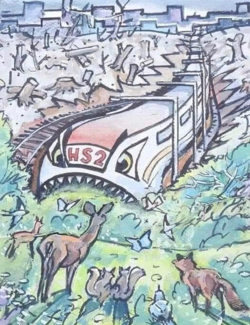
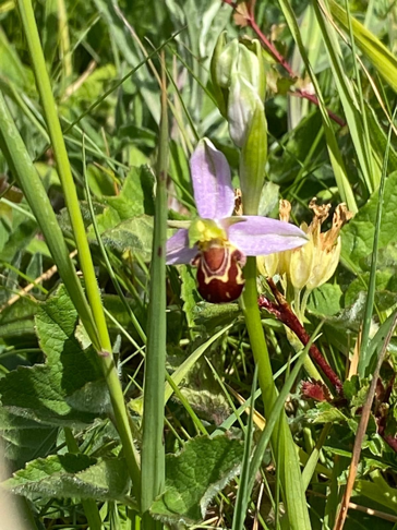
Will the EWR trains be friendlier to wildlife than this HS2 one? Find out from Kevin Hand on the 20th June.
On 20 June Kevin Hand will be doing a leisurely bike ride to some of the key wildlife sites mentioned in his Wildlife Impact Report for Cambridge Approaches and talking about the impact on them of the planned EWR Southern route and associated developments.
All welcome to come along for a chat at any point! 1030-1100 Nine Wells (Threatened) 1100 depart, cycle through Hobson’s Park (Threatened) then via Trumpington Meadows to the Granta at Hauxton Mill (Threatened) 1200 Harston church, walk to the site of the huge viaduct over the River Rhee (Threatened) Lunch break here. 1.30 Haslingfield church, walk to Haslingfield chalk quarry nature reserve and planned site of the Great Wall (Threatened) The orchids should be in bloom! 3pm Social gathering, Hare and Hounds, Harlton, in view of the southern route. 4pm Kevin will return to Cambridge via Toft village (Threatened) and Hardwick Wood (Threatened) finishing around 6pm
We have put together some short videos which summarise our campaign messages. Don’t forget to respond to the EWR Co. consultation which closes on June 9th 2021. Just say no to question 1!
East West Rail are planning to link Oxford and Cambridge by rail as part of the huge Ox Cam Arc development of new towns and villages.
A Consultation on the final route is open until 9 June.
This new Report for Cambridge Approaches covers the wildlife and environmental impact of the two routes into Cambridge from Cambourne: the Southern Route, which EWR seem to have already decided on, and the Northern Fenland Route, which includes Northstowe and seems to be favoured by a majority of those affected by these proposals. The report shows the Southern route has much greater impact on wildlife and landscape.
The Northern route is supported over the Southern one by every organisation involved in wildlife and landscape protection in the area, including the Bedfordshire, Cambridgeshire and Northamptonshire Wildlife Trust (BCNWT), the Woodland Trust, Cambridge Past Present and Future (CPPF) and the Countryside Restoration Trust. The government body charged with protecting nature, Natural England, has said “We are concerned at the apparent lack of an environmental justification for the discounting of route options to the North of Cambridge.”
It is important to note that the Consultation only asks people to consider the Southern route, not the Northern one. The route is only shown as a thin line on a map; it does not include the inevitable access roads, waste dumps, machinery parks and other infrastructure that will be needed nearby. It does not include impacts such as air pollution, noise and light pollution, toxic contamination, or changes to water quality and quantity.
Crucially it does not include any of the impact of the massive housing developments planned for the future. A stated aim of the Ox Cam Arc megaproject, of which this is a part, is to locate new development next to new transport infrastructure. One proposal, which has been put on hold for now at least, is for 25,000 homes (1), 5 times the size of Cambourne, in the Barrington area. Many other proposed new towns will follow, completely changing the character of the area and its villages. 1 million new homes are proposed within the Ox Cam Arc area by 2050 (one third of the total proposed for the whole of the UK).
East West Rail is already being dubbed Cambridgeshire’s own HS2.
If the project does go ahead, the environmental impact of the Southern Route will be much greater, and will have negative impacts on:
Cambridgeshire’s internationally important chalk streams, with their populations of Brown Trout, Water Vole and Otter, and the River Cam itself, already severely under pressure from water extraction for other new developments. There are only 200 chalk streams in the world and five will be affected by the Southern route:
The River Cam at Hauxton
The Rhee or Cam at Harston
The Riddy at Hauxton
Coldhams Brook
Hobson’s Brook which flows from the Nine Wells Local Nature Reserve into the city and beside the Botanic Garden, and was the first source of fresh drinking water for the people of Cambridge.
The West Cambridgeshire Hundreds Living Landscape, where the BCNWT is linking ancient woodlands like Hardwick Wood that have survived for hundreds of years. The proposed route will form a barrier for wildlife, and for people from Cambridge and its many new developments, no longer able to walk and cycle from the city to explore these areas or the associated Cambridge Boulder Clay & Woodland Priority Area identified as part of the Cambridge Nature Network by BCNWT and CPPF.
Our chalk hills and grasslands, one of the UK’s Priority Habitats, and in particular Haslingfield Chalk Pit and its associated landscape, which has thousands of orchids, including the nationally rare Man Orchid, and is widely valued and used by local communities.
The Bourn Brook, a site internationally famous for its success in restoring rare water vole populations and reducing introduced American mink, and the work of the Countryside Restoration Trust at Westfield Farm, whereover 20 years of research work have resulted in growing populations of rare farmland birds and plants.
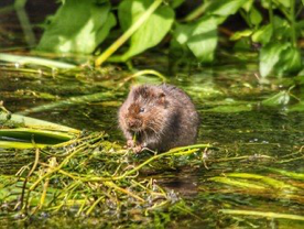
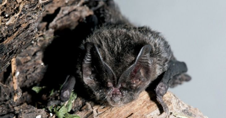
Many species of rare and endangered wildlife, including Barn Owls, Lapwings, Otters, Water Voles, Badgers and Bats. As just one example, the globally rare Barbastelle bat has a maternity colony centred on the Wimpole Hall estate and the Eversden Woods. This area has been awarded one of the UK’s highest levels of protection, a Special Area for Conservation. Feeding flights for the breeding mothers will be blocked, and bats may be killed, during the construction and operation of the Southern route. Many more less mobile mammals and birds will be greatly affected too. Mitigation for the Barbastelles suggested by EWR includes methods that have been shown not to work elsewhere, such as nest boxes and bridges(2).
Elms are a rare tree in the British landscape, and recent research has found 35 species in Cambridgeshire(3), many growing in woods and hedges that will be destroyed, including one found nowhere else in the world, Ulmus cantabrigiensis, the Cambridge elm.Rare black poplars are also to be found along the southern route.
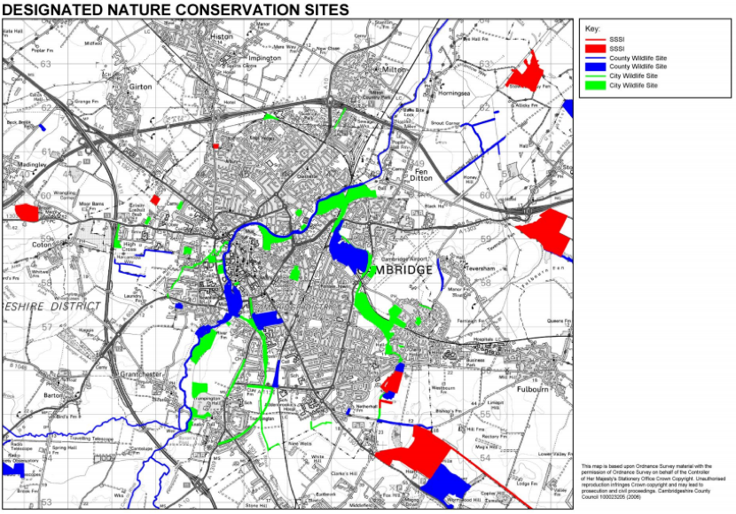
As well as the Special Area for Conservation at Wimpole, the Southern route will destroy or damage 2 Sites of Special Scientific Interest (SSSIs), at least 11 County Wildlife Sites and 3 City Wildlife Sites, vitally important green spaces for the growing population of Cambridge.
The Northern route is much less damaging to wildlife and landscapes, as it would cross the area already affected by the A14 upgrade, and a small part of agricultural fenland. It would not need to cross the River Cam. It should not affect any SSSIs, one or possibly 2 County Wildlife Sites, and no City Wildlife Sites.
However, both routes are likely to damage Coldhams Common and Coldhams Brook with its associated chalk stream network, a key recreational and wildlife site for the people of Cambridge. A large loop will need to be built here to allow freight trains to wait for a path through Cambridge; there has been little discussion about this major impact.
The rest of the Report gives more details on the impacts.
The author is:
Kevin Hand MSc MCIEEM Independent Ecologist Vice President, Cambridge Natural History Society Course Director, ACE Foundation and Stapleford Granary
“The second example is that of bat gantries (pictured), designed to reduce bat mortality on roads. Gantries, which are meant to guide bats to fly high enough over roads to avoid traffic mortality, were used in the UK for nine years without being tested, at a total cost of around £1 million. When studies were eventually undertaken, they found the gantries to be ineffective yet gantries continue to be constructed. Again, this is not due to a lack of available evidence, nor even to awareness of existing evidence; the gantry studies were widely reported in the national press, in relevant conferences and on television.”
3. Wildlife Trust BCN (2019). Here and Nowhere Else. https://www.wildlifebcn.org/blog/wildlife-trust-bcn/here-and-nowhere-else.
Figure 1. The Cam at River Farm with permission from Doug Thompson.
Main Report
1. Chalk Streams
There are only around 200 chalk streams left in the world and 85% of them are in southern England.
The unique characteristics of chalk streams, with their pure cool water, support a wide range of flora and fauna, from plants such as Water-crowfoot, Lesser Water Parsnip and Water Starwort, to a diverse collection of invertebrates and fish including the iconic Brown Trout. A chalk stream teeming with life is also attractive to Water Voles, Kingfisher and Otter. The unique and diverse ecology of chalk streams makes them a globally rare, and globally important, habitat. It could be argued that chalk streams are our local equivalent of rainforests.
The chalk streams affected by the SOUTHERN ROUTE are detailed in the recent Greater Cambridge Chalk Streams Project Report produced for Cambridge City Council and Cambridge Water by Ruth Hawksley at the BCN Wildlife Trust and Rob Mungovan of the Wild Trout Trust(1).
Five chalk stream sites will be affected by the SOUTHERN ROUTE, namely:
The River Cam at Hauxton, which has Otter, Brown Trout and Brook Lamprey, a rarely seen and ancient fish which lives most of its life without eyes or mouth.
The Rhee or Cam at Harston, also with Otter and Brown Trout.
The Riddy at Hauxton.
Coldhams Brook, which has Water Voles and Otter, both unusual in an urban environment.
Hobson’s Brook which flows from the Nine Wells Local Nature Reserve (LNR) into the city and beside the Botanic Garden, and was the first source of fresh drinking water for the people of Cambridge. Nine Wells LNR is a County Wildlife Site (CWS), and was formerly a Site of Special Scientific Interest (SSSI). It is also part of the Gog Magog Countryside Project connecting it with Wandlebury.
Brown Trout are just starting to return to the area as water quality slowly improves. Otters are a protected species under the Wildlife and Countryside Act 1981, also returning after an absence of many years. Water Voles are also protected under the Wildlife and Countryside Act 1981. They are one of our fastest declining mammals, but are also present in good numbers. Both are found in all 5 of the chalk streams that will be affected.
Figure 3. Rhee southern crossing point by Kevin Hand.
Beside the Rhee, at the SOUTHERN ROUTE crossing point, is a complex of wet meadows and wet willow woodland, probably the rarest UK woodland type. Both are Priority Habitats. This area would qualify as a CWS on its own merits. The author noted breeding evidence of Cetti’s Warbler here, probably a new county record, and singing Grasshopper Warbler. The woodland and associated mature willows have potential as a breeding site for the endangered Lesser Spotted Woodpecker.
The national Chalk Stream Alliance is fighting to protect the remaining streams. Locally the Cam Valley Forum (https://camvalleyforum.uk) is working to combat threats such as this kind of development. On 21 June 2021 the Friends of the River Cam are launching the Rights of the River Cam.
The NORTHERN ROUTE does not affect any chalk streams, and does not affect the River Cam, except in that both routes can impact Coldhams Brook and Coldhams Common by building a loop of track there so that large freight trains can turn around. This could be avoided if a loop is built outside Ely instead.
All the streams and river sections listed are going to be affected by the SOUTHERN ROUTE. Particular damage can be done during the building works by things such as increased sediment load, pollution and the disruption of hydrology. Noise and light pollution disturbing breeding birds and mammals would also be a particular issue.
Otters are fully protected under the Wildlife and Countryside Act 1981. They are highly secretive when breeding, and cover a wide area, often up to over 35km of riverbanks, so laws protecting them could easily be broken. All nesting birds are protected, again under the Wildlife and Countryside Act 1981, so no work could be done during the breeding season, from at least March-July, without breaking the law. No licences are available to destroy or disturb birds’ nests. Special species, like Kingfisher and the wetland warblers present such as Sedge, Reed and Cetti’s, have nests that are particularly hard to find.
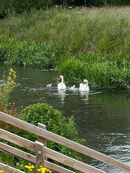
Figure 4. Swans, with permission from Doug Thompson
2. Hardwick Wood and the West Cambridgeshire Hundreds Living Landscape
(A) Hardwick Wood
This is an ancient ash and field maple woodland, with nationally rare Oxlips (Primula elatior), and is managed by the Bedfordshire, Cambridgeshire and Northamptonshire Wildlife Trust (BCNWT) as a nature reserve. Recent changes to the National Planning Policy Framework for England planning laws state that “ancient woodland should not be affected by any development”. It is also a Site of Special Scientific Interest (SSSI), often referred to as the Crown Jewels of nature sites in Britain, and specifically protected by planning laws.
“Hardwick Wood has the sinuous outline of medieval woods and is surrounded by a substantial wood bank, well preserved on the south and east sides. After ceasing in the early 20th century, coppicing was reinstated in 1979. This traditional practice lets in more light to the benefit of flowers and insects. As the coppice grows it provides safe nesting sites for woodland songbirds such as willow warbler, marsh tit and blackcap. The large amount of dead wood is a boon for the woodpeckers that can be heard drumming in spring.The Mere Way runs along the western boundary, the banks of the adjoining ditch providing a haven for cowslips and the rare crested cow-wheat, usually found on the margins of ancient woodlands and in clearings and rides. As twilight descends, the hoots of owls can be heard and bats patrol the woodland edges in their search for food.”
The SOUTHERN ROUTE does not cut directly through the Wood, but goes close enough to have a significant impact on it, especially during the construction phase. It will also cut through wildlife corridors associated with the Wood, reducing its wildlife value. As there is no indication where associated works will be, it may be that access roads, waste dumps, spoil pits etc have further impacts upon the Wood and its associated habitats. As such, it will impact on the West Cambridgeshire Hundreds project.
(C) The West Cambridgeshire Hundreds
These are a collection of wildlife-rich ancient woodlands in an area defined for over 1000 years by the old Anglo-Saxon regional divisions known as the Cambridgeshire Hundreds. It’s thought the word ‘hundred’ came from an area of land that could supply 100 warriors in times of war.
This is a joint project between the BCN Wildlife Trust, local landowners, the Farming and Wildlife Advisory Group East, the National Trust, Natural England, the Forestry Commission and the Woodland Trust. The Scheme area extends to 20,000 Ha.
The SOUTHERN ROUTE may also impact two nearby County Wildlife Sites (CWS). CWSs are areas of land in Cambridgeshire important for their wildlife, selected by the combined expertise of the BCN Wildlife Trust, Farming and Wildlife Advisory Group, Natural England, Environment Agency, local authorities and the Cambridgeshire and Peterborough Environmental Records Centre (CPERC).
Jason Farm Grassland CWS is just north-west of Hardwick Wood. This site is notified because it has 0.05ha of the National Vegetation Classification (NVC) community MG5 Crested Dog’s-tail (Cynosurus cristatus)) – Black Knapweed (Centaurea nigra) grassland.
Frogs Hall Drift CWS is south of Hardwick Wood and supports frequent numbers of at least eight neutral grassland indicator species and populations of Nationally Scarce vascular plant species (Sulphur Clover (Trifolium ochroleucon); Yellow Pea (Lathyrus aphaca);Slender Tare (Vicia parviflora);Purple Fescue (Vulpia ambigua ssp. Ciliata – taken from CPERC records)).
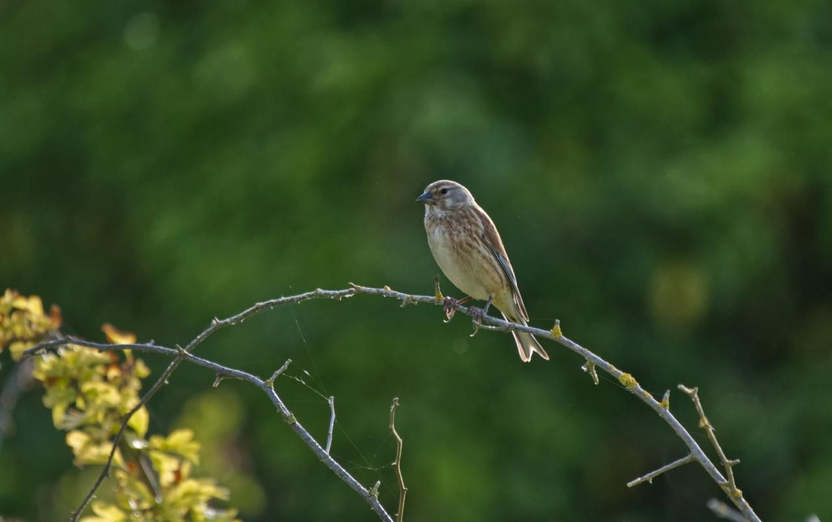
The author found breeding evidence of Corn Bunting (Emberiza calandra), Skylark (Alauda arvensis), Yellowhammer (Emberiza citronella) and Linnet (Linaria cannabina) in the area. All are classified as Red under the Birds of Conservation Concern 4: the Red List for Birds, and are Priority Species under the UK Post-2010 Biodiversity Framework.
Figure 5. Linnet (Linaria cannabina), with permission from Douglas Thompson.
(D) Cambridge Nature Network
BCNWT, working with Cambridge City Council and others, have identified the landscape west of Cambridge as having significant potential to connect Cambridge to the West Cambridgeshire Hundreds, for the benefit of wildlife and people.
“The EWR favoured Southern route from Cambourne to Cambridge fundamentally compromises this goal of creating landscape scale connections … in this part of Cambridgeshire in providing a pleasant and largely undeveloped green lung accessible to the people of Cambridge.”
“The proposed route will in effect form a barrier for some wildlife and most definitely for people between the West Cambridgeshire Hundreds and the Cambridge Boulder Clay & Woodland Priority Area identified as part of the Cambridge Nature Network. The barrier will also separate the people of Cambridge from the West Cambridgeshire Hundreds, in that attractive non-motorised travel routes will be severely degraded or even cut off.”
Source: Martin Baker, Conservation Manager, BCNWT
3. Chalk Hills and Grassland
Cambridgeshire’s ridge of chalk hills, running here from Wimpole to the valley of the Cam at Haslingfield, are a highly visual highlight of the county’s landscape. They were formed in the Cretaceous period between about 90 and 99 million years ago, mostly from the remains of marine algae and various animals that sank to the bottom of a warm, deep sea. Rain filters through them to feed the chalk streams, and their aquifers supply much of our drinking water. Chalk grassland is only found in north-west Europe, and a significant proportion of this is in the southern counties of England. Chalk grassland has declined by an estimated 75-80%since the Second World War.
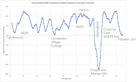
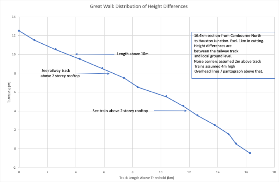
The SOUTHERN ROUTE from Cambourne to Harston contains a huge embankment, viaduct and cutting complex dubbed the Great Wall of Cambridge, which will transform the landscape. This route will cut through the chalk hills from Harlton to Harston, and will include a deep cutting through the historic Chapel Hill, the famous ridge that stands above the village of Barrington. Once changed, this landscape can never be restored.
Figure 6. Elm Woodland on Chapel Hill by Kevin Hand.
The chalk soils form another Priority Habitat under the UK Biodiversity Action Plan and the Natural Environment and Rural Communities Act. The roadside verges at Chapel Hill are rich in chalk flowers, and should qualify as a County Wildlife Site.
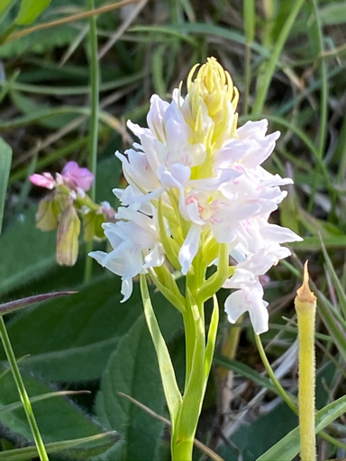
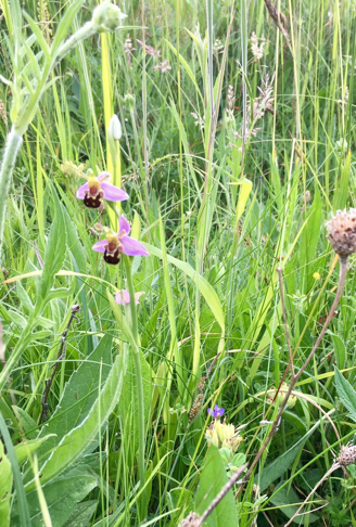
Nearby Haslingfield Pit is a CWS, notified because of the thousands of rare orchids that grow there, in particular the Man Orchid, listed as Nationally Scarce. Other orchids include Common Twayblade, Bee Orchid and Common Spotted Orchid. They are counted annually by local volunteers led by Clive Blower. In 2017 the totals were:
Man Orchid (Orchis anthropophora) – 75
Bee Orchid (Orphrys apifera) –12
Common Twayblade (Neottia ovata) – 606
Common Spotted Orchid (Dactylorhiza fuchsia) – 1515
Haslingfield Pit is widely used for recreation and relaxation by locals and visitors. It has the potential to expand into neighbouring areas, including the field margins nearby, which also potentially hold rare chalk flowers.
Also likely to be affected by the SOUTHERN ROUTE is the nearby Barrington Chalk Pit SSSI. This is a ‘Geological Conservation Review’ site, and is noted as the last remaining exposure of the famous Cretaceous ‘Cambridge Greensand’. The site has great stratigraphical importance for studies of the Upper Cretaceous of eastern England.
The area is also noted for its wildlife interest, with protected species such as Peregrine Falcon (Falco peregrinus) and Raven (Corvus corax) nesting nearby, and many rare elms growing in the hedges.
4. Bourn Brook, the Countryside Restoration Trust land at Westfield Farm, Comberton, and nearby County Wildlife Sites
(A) Bourn Brook
Bourn Brook is part of the same network as the chalk streams that flow into the Cam, but is classified as a clay stream as it runs mainly beneath the chalk hills, all the way into the outskirts of Cambridge at Byron’s Pool, Grantchester. The SOUTHERN ROUTE will cross it south of Toft, with a huge potential impact on its wildlife and ecology.
Bourn Brook is internationally famous for its Water Vole conservation work, led by Dr Vince Lea and the Countryside Restoration Trust (CRT). Their project to eradicate introduced American Mink, Bourn Free, has been widely publicised and admired for its ground-breaking success. As a result, Water Vole numbers have increased such that every available habitat along the Brook is now occupied, with a similar increase in water birds and particularly Otters. Otters are rarely seen so their numbers are estimated by the number of spraints (droppings marking territory), which increased from 11 in 2011 to 90 in 2017. The project is described in detail in an article by Dr Lea(2) in British Wildlife in December 2020. Water Voles can, in theory, be moved elsewhere from a site that is threatened with destruction, when Natural England give developers a licence to do this, except that all suitable habitat nearby is already occupied. Otters cannot be subjected to licensed removal, and there is no mitigation possible for the thriving populations living here.
Otter and Water Vole conservation is just part of the work of the Countryside Restoration Trust, whose Westfield Farm at Comberton will be cut in half by the SOUTHERN ROUTE. The CRT statement on this gives an excellent overview of the impacts on the wildlife of the area, and we quote extensively from it here.
“ The latest preferred route option is potentially disastrous for nature and wildlife habitats in the Cambridge area.
The rail link’s proposed route will directly and negatively impact wildlife habitats and species numbers and divide habitat corridors throughout the area. The route could destroy 27 years of endeavour to increase national declining species on CRT land at Westfield Farm in Comberton.
We have been approached to have environmental studies on our land at Westfield Farm, Comberton, in 2021. The East-West Railway project has recently released an interactive map showing the route in a blue-grey proposed area (and layers of land designation can be highlighted).
Westfield lies south-west of Comberton, and despite being listed as a ‘Priority Habitat’ (by Natural England) and a Greenbelt area (by The Ministry of Housing, Communities and Local Government’s formerly the Department for Communities and Local Government) which is specially designated area of countryside protected from most forms of development, the route dissects through the land.
The concern is that this devastates CRT land and other habitats, reserves, and local homes. We join other organisations suggestions that the railway line should follow the A428 and not obliterate the precious rural countryside to the west of Cambridgeshire.”
Again, quoting extensively from the CRT statement, and using their images, we note the extensive number of species that will be impacted by this development.
“We are extremely concerned about the impact the East-West Railway project will have on the habitats of protected, rare and farmland species. These include many BAP species identified as being the most threatened and requiring conservation action under the UK Biodiversity Action Plan (UK BAP).
Birds
Yellowhammer (in the top 1% of sites nationally 2019)
Grey partridge (in top 1% of sites nationally 2019)
Corn Bunting (numbers in the top 10% of sites nationally 2019)
Skylarks (numbers in the top 10% of sites nationally 2019)
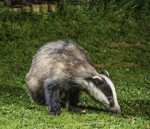
At least one Badger sett with activity in other areas suggesting possibly a secondary sett developing. It is against the law, under the Protection of Badgers Act 1992, in England and Wales to disturb a badger and intentionally or recklessly damage or destroy a badger sett or obstruct access to it.
Figure 10. Badger, with permission from Douglas Thompson.
Bats are not systematically recorded but are seen, Pipistrelles particularly. Also, there are recorded sightings of the Barbastelle bat.
(C) Bourn Brook through Westfield, reptiles, butterflies and plants
Again, we quote extensively from the CRT statement on the biodiversity present.
“The Bourn Brook’s riparian habitat that runs through Westfield is regularly monitored and maintained to create habitats for declining species and remove invasive species.
Water Voles have colonised the site following work on the Bourn Brook to remove the invasive American Mink. Through a collaborative project, started in 2011, called the Bourn Free project, thelocal numbers of Water Vole has risen on other parts of the Bourn Brook that flows through Lark Rise Farm, CRT land in Barton.
Westfield was the site where the first live-sighting of a wild, native Polecat was made in Cambridgeshire when one entered one of our mink traps and was released back into the wild following photographs as a record of the sighting.
There is a regular survey of butterflies on the site, with nearly 20 years of data fed into the national butterfly monitoring scheme. This long-running data set would be threatened if a railway line crosses the site. While most species recorded are common and widespread, we have a good assemblage of species, including Small Coppers, Marbled Whites and Purple Hairstreaks.
Near to Westfield Farm are another two County Wildlife Sites that will be impacted:
The Radio Telescope area west of A603
This supports over 0.05ha of the NVC community CG3 Upright Brome grassland.
Lords Bridge Observatory
Situated east of the A603, this supports frequent numbers of at least 3 strong neutral grassland indicator species. Additionally it supports a population of the Nationally Scarce vascular plant species Slender Tare (Vicia parviflora). It is a large site at 34 ha.
The sides of A603 here are Protected Road Verges for similarly valuable neutral and calcareous grassland.
5. Endangered Wildlife, including Barbastelle bats
Many species of endangered and protected wildlife will be killed by the SOUTHERN ROUTE. Most of these are listed under their sites mentioned above.
In addition the route includes good populations of Water Vole, Otter, Brown Hare, Badgers and Bats. The last two are dealt with in more detail below. Rare species such as Marsh Harrier, Red Kite, Raven and Peregrine Falcon breed along the route: their locations are not publicised. Barn Owls nest in many places along the route, as do Grey Partridges, Skylarks, Yellow Wagtail, Lapwing, Yellowhammers, Bullfinch, Dunnock, Reed Bunting, Song Thrushand Linnets, all Red List farmland bird species of conservation concern. There are good populations of Whitethroat, Blackcap and Chiffchaff, and smaller numbers of Willow Warbler, Lesser Whitethroat, Sedge Warbler and Reed Warbler, as well as many other scarce bird species that use the many hedges and woodland strips along the route.
All birds and their nests have protection under the Wildlife and Countryside Act, with no Natural England licences available to exempt developers from the unlimited fines available for nest disturbance or destruction. This means all work should stop whenever birds are nesting, roughly half the year, adding considerably to the time needed to complete the project.
The NORTHERN ROUTE also has nesting birds, but overall the numbers are likely to be less, with fewer species of special importance, particularly as much of the land is urban, suburban, already developed, or intensively managed farmland with few hedges and woods. Badgers do occur in reasonable numbers in the Dry Drayton area, but much less so on the drained fen farmland. Bats are likely to show a similar distribution, but more work should be done to confirm this. Otters are likely to be absent from the route, and Water Voles extremely scarce.
(A) Bats
All bat species are scarce and endangered, with some being our rarest animals. All are protected under the Wildlife and Countryside Act 1981, along with their roosts in trees and buildings. As with all the other wildlife recorded, it is likely that bat numbers affected are much greater along the SOUTHERN ROUTE. Many will roost in mature trees that will be felled, particularly Noctule, Long Eared and the two Pipistrelle species, with others roosting in woods, and for the last three species, some of the houses that will be destroyed.
The UK is a signatory to the Agreement on the Conservation of Bats in Europe, set up under the Bonn Convention. The Fundamental Obligations of Article III of this Agreement require the protection of all bats and their habitats, including the identification and protection from damage or disturbance of important feeding areas for bats.
It is worth noting that bat roosts are notoriously hard to find. Many developers employ ecologists who will survey for bat roosts. This involves waiting beside potential roost trees at dusk or dawn, with audio bat detectors, in the hope of seeing or hearing the very fast emergence of the bats, which takes a matter of seconds. It is easily missed. With so many trees to look at it is highly unlikely that all bat roosts will be found before tree felling begins.
(B) Barbastelles(Barbastella barbastellus)
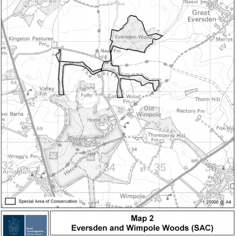
Of particular importance, South Cambridgeshire is home to a large breeding colony of one of our rarest bats, the Barbastelle. The Wimpole Estate and Eversden Woods are protected for this reason with one of the highest UK designations, a Special Area of Conservation (SAC) https://sac.jncc.gov.uk/site/UK0030331
Figure 12. Barbastelle Bat
Although the works associated with the SOUTHERN ROUTE will hopefully not destroy this area directly, Barbastelles feed at traditional sites some distance away in rural landscapes with deciduous woodland, wet meadows and water bodies. Barbastelles tolerate only minimal disturbance within 2 km of their roost. They can forage up to 20km from their roosts but more typically venture around 6-8km. They commute to foraging sites along linear landscape features, such as woodland edges and hedgerows, similar to the hedgerows that act as wildlife corridors. They have also been known to cross open areas such as arable fields to reach foraging grounds.
In 2008, a proposal for 8 wind turbines on land at Merry’s Farm, Great Eversden, was put to the landowner but not carried out because Natural England stated that “Separate to any Environmental Impact Assessment undertaken there will also need to be an Appropriate Assessment for the proposal under the Habitats Regulations. For the proposals to pass this assessment it will have to be conclusively shown that there will be no impacts on the integrity of the site (i.e. on the barbastelles for which the site is designated) arising from the development. If there is any uncertainty about such impacts, then the proposal is unlikely to pass the assessment.”
In addition “giventhe international importance of the site and the acknowledged deficiencies in current scientific knowledge, we would also expect to see more innovative methods of survey employed to detect activity at turbine height (e.g. using remote systems or radar). In order to provide a robust evidence base to meet the requirements of an AppropriateAssessment, we would suggest that at least 3 yearsworth of survey datawould be required.”
Source: This information has been shared with CA by Jane Rolph of Merry’s Farm.
The same level of compliance must be needed for the railway and its ‘Great Wall’ viaduct and all other associated works. Three years of intensive survey would significantly delay the project and increase the costs, and the results may well mean this route is rejected.
Disruption to the foraging routes and flight lines could have a potentially significant impact on the Barbastelle bats foraging habits, particularly impacting on the breeding females, putting at risk the maternity colony and, thus, ultimately the species. The species is very sensitive to disturbance, including disturbance to roost sites and access to food resources, which may be why it is such a rare bat. The Barbastelle is on the International Union for Conservation of Nature’s Red List of Threatened Species, where it is classified as ‘near threatened’ with extinction (IUCN Red List 2020).
Much radio tracking work has been done on the areas the breeding bats use when feeding their young, and many of these lie directly along the planned works. Other areas are the other side of the route, and there is good evidence that bats cannot cross these kind of large transport routes, and risk death if they try. The gantries proposed by EWR have been shown not to work see Sutherland & Wordley, 2017(3).
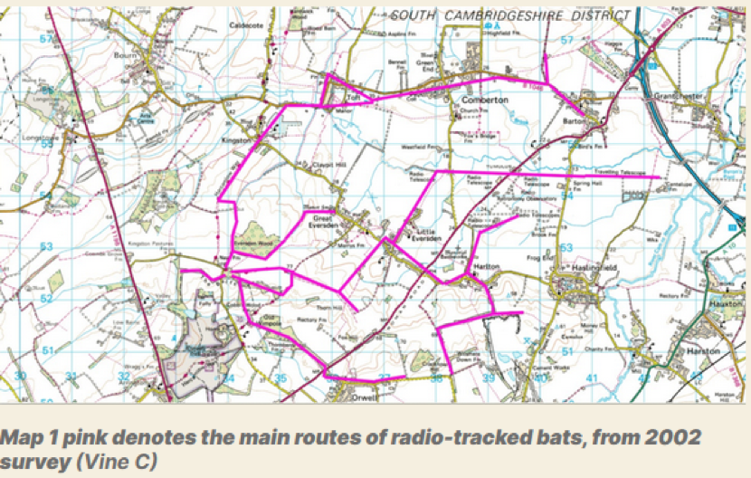
Damant & Vine (2006)(4) stated the following:
“After another hour or two these bats would make excursions to the east, towards Cambridge. The favoured route for some bats was the old railway line with the radio telescope dishes; this also had tall neglected hedges either side and semi-natural grassland (another good source of micro-lepidoptera). Other routes were along Bourn brook and other tall hedges. The small villages of Toft, Kingston, Comberton, Barton and Harlton were also favoured. In 2003 one bat used Harlton quite frequently, including the old chalk quarry with its secondary growth of woodland and the tall hedges in and around the area.
… The Barton area was extensively used by a single bat which sometimes flew to Barton, back to the maternity roost woodland and back to Barton in one night. It is very probable that these trackways are used because of the natural grassland margins, their quietness and also the fact that they may actually accumulate wind blown invertebrates from the surrounding arable land. Simon Damant has witnessed this in another trackway used by Pipistrelles where a short section had a tall hedge in a predominantly open landscape a long way from buildings and woodland.
… To some extent the Wimpole population follows this basic assumption in that they do use Bourn Brook and go into Grantchester where the River Cam joins the River Rhee, almost certainly relying on the adjacent meadows to the waterways for a rich source of food. The small River Rhee catchment and Bourn Brook seem to be the main areas for foraging, though villages to the east are also frequented. However, in a much modified human landscape the bats would seem to have also adapted to using the more unkempt wider and taller boundary hedgerows with woodland copses for their flight lines and foraging in south west Cambridgeshire. They have also used the disused railway lines which have developed a secondary tree growth and tall hedgerows with semi natural grasslands. It is important to note that southwest Cambridgeshire is well wooded compared with much of the rest of the county but even here woodland is sparse and not particularly well linked by good tall and wide hedgerows.
… Therefore absolutely any woodland loss within a radius of 10-15km could be of great significance for the viability of the population of Barbastelles at Wimpole.”
It is recommended by the Conservation of Habitats and Species Regulations 2017 that large infrastructure projects that could impact an SAC, whatever the distance, should undertake a Habitats Regulation Assessment. This has not been done, for either route. The Habitats Directive includes protection of the habitat, including the flight and foraging lines upon which the bats rely to successfully breed and rear young. Natural England have stated: For this reason, Natural England would advise that an Evidence Plan should be agreed with the relevant statutory bodies in order to inform EWR Co.’s approach to complying with the Habitats and Wild Birds Directives.
Source:Natural England response to the non-statutory consultation 2019, page 254.
This draws on the work of the Cambridgeshire Bat Group in radio tracking barbastelles from the SAC maternity colony (Vine 2002)(5). This showed their flight and foraging lines include the Bourn Brook corridor and the River Rhee/Cam, as well as the two CWS sites at Lords Bridge and the Radio Telescope line.
Note that this work would need to be brought up to date by EWR before they could make any suggestions of mitigation, tunnels or gantries, even though these have been shown not to work.
(C) Badgers(Meles meles)
Badgers are abundant along the Southern Chalk Hills route. The Cambridgeshire Mammal Group are aware of at least 20-30 family groups that will be impacted, and note that many more families are unrecorded. These families can have over 30 members. The average is 5- 8 adults per family, plus young, so an estimated 150 badgers at least could be affected, perhaps over 500.
Many fewer badgers will be affected by the NORTHERN ROUTE, with few badgers in the fens themselves.
Badgers are protected from death and destruction of their homes under the Protection of Badgers Act, 1992 and the Wildlife and Countryside Act, 1981. However developers are often able to appeal to Natural England, the government body involved in protecting nature, and NE will give them licences, not to kill badgers directly, but to block them from their homes, known as setts. This is done by covering the setts with thick mesh, and putting one-way gates on the remaining sett entrances, so they can leave but not return. As badgers spend the daytime hiding underground in their setts, there is little information on how they survive when they cannot access them. Anecdotal evidence suggests many badgers are killed by cars as they attempt to find new places to live. Because they are highly territorial, they will not be tolerated by other badgers living nearby, and may have to travel long distances, presumably hiding out above ground each day as they go, until they find an unoccupied area with enough food and a place to dig a new sett. Developers are supposed to provide some artificial setts for them nearby, but rarely enough for the number of badgers displaced, and in practice distressed badgers often reject the man-made setts.
Along the 100 miles of the HS2 route currently under construction, just 4 man-made setts appear to have been provided so far, with many hundreds of badgers evicted.
(D) Polecat(Mustela putorius)
The native British Polecat is only now returning to Cambridgeshire, with some of the first sightings in areas along the SOUTHERN ROUTE. This rare and secretive mammal was persecuted to extinction in England in the past, and is supported in its natural reintroduction by the national Mammal Society and many other conservation groups.
(E) Elms
Elms are a rare tree in the British landscape, decimated by Dutch elm disease in the 1970s and beyond. Recent research by Brian Eversham, CEO of BCNWT, has found 35 species in Cambridgeshire, many growing in woods and hedges that will be destroyed, including one found nowhere else in the world, Ulmus cantabrigiensis or the Cambridge elm.
Running along the summit of Chapel Hill, Barrington, is a particularly impressive mixed elm woodland with many mature trees. Many other mature elms are found in hedges and woodlands along the route, along with smaller hedgerow trees, which have the potential to grow into large trees.
(F) Oaks
There are many other mature trees along the route, most of which would qualify for Tree Preservation Orders. Of particular note are the many ancient oaks, many of which mark field and parish boundaries.
The hedges between Barrington and Harston have recently seen the planting of 300 oaks by community volunteers as part of the national Save the Oaks campaign (www.savetheoaks.org). The trees were planted in memory of those who died during the Covid pandemic.
(G) Black Poplars (Populus nigra)
Black poplars have been reported along the SOUTHERN ROUTE, particularly in the Radio Telescope area. These are one of Britain’s rarest trees, with an estimated population of around 600.
6. Coldhams Common and the City Wildlife Sites
(A) Coldhams Common
Coldhams Common is protected as a County Wildlife Site, and is widely used by the people of Cambridge, including those from areas with less direct access to green spaces, such as Abbey and Romsey. Many enjoy access to the outdoor sports facilities here, and there are large areas used for healthy walking and exercise. A new community farm, CoFarm, has recently been set up by volunteers to grow and provide fresh organic food for those who are in need. The Friends of Coldham Common group represent local communities who use and value the area.
Coldhams Common has a rich wildlife biodiversity, particularly for an urban area. Amongst the breeding birds are many warblers, which migrate here annually from Africa, including Chiffchaff, Blackcap, the scarce Lesser Whitethroat and Goldcrest. The city’s resident Peregrine Falcons hunt over here, and other rare birds like Osprey and Hobby have been sometimes noted.
The area likely to be affected, by both routes, is where the Coldhams Brook (described above under Chalk Streams) runs through the Common, near the Abbey football ground. Here, large freight trains will need a loop of new track built to allow them to wait for a path through Cambridge. Few details have yet been provided by EWR about this. It could have a large impact on that part of the Common, and on the ecosystem and hydrology of Coldhams Brook.
(B) Other Cambridge Wildlife Sites
Source: Cambridgeshire Green Infrastructure Strategy; Cambridgeshire Horizons (2011)
One other CWS (shown in blue above) is likely to be highly affected, and almost certainly destroyed, by the SOUTHERN ROUTE. This is the triangle of woodland beside the existing railway and guided busway, north of Long Road, known as Long Road Triangle CWS. The site qualifies as a County Wildlife Site because of the presence of a Nationally Scarce vascular plant species, Spreading Hedge Parsley (Torilis arvensis), but it is also an important piece of scarce undisturbed woodland in the city. The SOUTHERN ROUTE will require expansion of the existing railway line, destroying this site and its neighbour, below.
Long Road Triangle is given extra value because it joins a City Wildlife Site (CiWS), Long Road Plantation, just south of Long Road. CiWS are designated by the same body as the County Wildlife Sites, and are important urban wildlife refuges. Long Road Plantation qualifies because it is a woodland of over 1ha and has five or more characteristic woodland plant species.
Moving further south along the existing line, which will be widened, the next City Wildlife Site under threat is Hobsons Brook. This has a higher status as a Chalk stream (see above)together with its adjacent habitat. There is a very high risk it will become contaminated by sediment and debris during the building work.
Nine Wells was a geological SSSI, and is a main source for the Hobsons Brook chalk stream. Adjacent to it is Red Cross Lane Drain (TL465547), a CiWS that supports several neutral grassland indicator species in good numbers. Both sites are likely to be highly damaged by the expansion of the adjacent railway line.
Since these sites were designated a new area of high wildlife and public value has developed at Hobsons Park. It has a large amount of wildlife of interest, and is much used by the people of the city. In just one recent visit the author noted breeding evidence of Reed and Sedge warblers, Corn and Reed bunting, Yellow Wagtail, Skylark in large numbers, Meadow Pipit, and a large Black Headed Gull colony, with Common Terns also likely to breed. Hobsons Brook runs through the site. Expansion of the railway and associated works are likely to have a high impact on this important site.
7. Northern Route Wildlife Sites
The only SSSI near to the NORTHERN ROUTE is Madingley Wood, just over 2 km away, but separated from the route by the A428 dual carriageway. Because of this it is unlikely to be impacted by the route works
There is a Roadside Verge CWS south of Knapwell near the A428 crossing that supports populations of Nationally Scarce vascular plant species including Sulphur Clover (Trifolium ochroleucon) and Crested Cow-wheat (Melampyrum cristatum). This site could be damaged or destroyed.
Also along the route is Beach Ditch and Engine Drain CWS south of Cottenham, designated for its wet ditch flora and fauna. Again this could be damaged or destroyed.
Other impacts of the NORTHERN ROUTE are also much less, and are mentioned above.
Kevin Hand MSc MCIEEM May 2021 Independent Ecologist Vice President, Cambridge Natural History Society Course Director, ACE Foundation and Stapleford Granary
Acknowledgements
Many thanks to all at Cambridge Approaches, particularly Dr Anna Gannon, Dr William Harrold, Pippa Keynes, Dr Sharon Erzinclioglu and Angela Thompson; the Cambridge Bat Group; and the Cambridge and Peterborough Environmental Records Centre (CPERC).
Damant, S. & Vine, C. (2006). The Barbastelle at Wimpole. Nature in Cambridgeshire48: 60-64.
Vine, C. (2002). A. study of Barbastelle bats at Wimpole, Cambridgeshire, July 2000 to August 2002. Report to Natural England. Available from Natural England on request or directly from the National Trust.
Figure 1 San Jose, Silicon Valley. A vision of Cambridgeshire in 2050?
Introduction
The EWR Co. 2021 non-statutory consultation includes a policy statement[1] on noise and vibration in which we find the following statement. “Sometimes we will need to elevate the track, for instance when trains intersect with roads and cross land in a floodplain. However, where it’s practicable we will consider building the track low in the landscape. This can help reduce noise and has the benefit of reducing the impact on the landscape.”
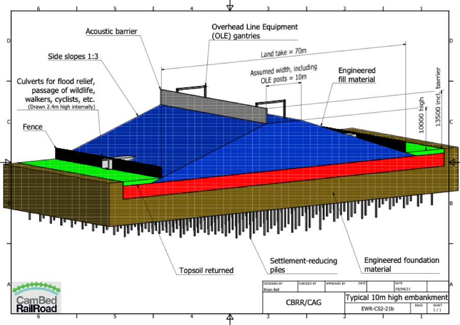
Although they recognise that it is good to build low in the landscape (and as we shall see, this is good for several more reasons than just noise and vibration), the circumstances where they elevate the railway occur frequently. This has resulted in proposals for the approaches to Cambridge, north or south, which can only be described as a desecration of the landscape in our precious green belt. Indeed, it is hard to overstate the hideous nature of the proposals that we have before us.
This post has been written with the guidance of experienced civil engineers and the hope is to help EWRCo. find a better solution. But it is also to explain to others what is possible and is achieved elsewhere in the world and so to set all our expectations a lot higher. CBRR have, as volunteers, looked at a low impact railway design for the northern approach, but have not done so for the southern approach.
But before we get into all that, we start with some important background.
Background: Number of Houses in Cambridgeshire to Double by 2050
The EWR project forms part of Whitehall’s OxCam ARC initiative as set out in their National Infrastructure Commission (NIC) report[2] and confirmed in the recent OxCam Spatial Framework 2021 from the Ministry of Housing, Communities and Local Government (MHCLG)[3]. The NIC report (p.28) envisages building 1 million homes in the Arc between now and 2050 and in particular 271,000 in an area approximating to Cambridgeshire.
Since the area in the NIC report is not the same as the county of Cambridgeshire the percentage increase between the baseline date of 2014 and 2050 is harder to estimate from publicly available figures, however and Oxford Professor David Rogers has stated that it represents an 81% increase. The recent rate of housing growth will soon have to double to make that target by 2050.
The average home in the UK generates over 50 tonnes of CO2 in construction and emits a further 2.7 tonnes per year[4]. That’s 26.7 million tonnes of CO2 between 2014 and 2050 for construction and a rate of emission of 0.73 million tonnes / year after 2050 excluding any further construction. We cannot go on like this.
The population of the UK is forecast to grow by 16% by 2050 with the addition of 3 million homes. Therefore, the 1 million homes in the Arc is one third of the number for the whole UK and is concentrated in just 4.7% of the UK’s land area. The NIC report refers to this “transformational” growth, way beyond anything needed to serve existing residents. We will be transformed into an urban sprawl from Oxford to Cambridge – see Figure 1. Who does this benefit? Not local residents. I suggest that local politicians consider who they are elected to represent. We do not want this.
The OxCam Arc plan is for Cambridgeshire to grow much, much faster than the UK average. The OxCam Spatial Framework plans to create 1.1 million new jobs. We are talking about a lot of people moving into the area. Everyone should be interested in the environmental impact of this and we recommend watching the talk given to the Friends of the Cam recently by the Oxford Professor of Ecology David Rogers who provided many of the insights above.[5]
Our local environment and residents are in for some cruel and unusual punishment if the OxCam Arc goes ahead and EWR Co.’s project is a core part of it.
Yes, we need more houses and we need better transport for local commuters, but the plans for the OxCam Arc go way beyond that. Perhaps Whitehall have the scene in Figure 1 in mind for the whole OxCam Arc and Cambridge in particular. How long will even the green belt last?
Incidentally, how can anyone plan, propose, decide or even comment on the route of the railway when there is no plan for where these 271,000 additional houses are to be built?
Why talk about this in the context of a post about ‘low Impact design for railways’? Well, most of the Cambridge Approaches material is working on the premise that the EWR Central Section does have a sensible triple (profit, people, planet) bottom line case and, given that it will be built, we are looking at where might be the most sensible place for it to go based on available information. Put another way, we are addressing the proposition in front of us. However, we will just make two points.
If there is a business case for the Bedford to Cambridge section it will be predicated on this massive housing growth and EWR Co. are therefore in no position at all to take the any moral high ground on CO2 emissions.
To encourage all these people to want to work in the area the railway needs to be attractive as specified in the Sponsors Requirements[6]. The Great Wall, huge grade separated junctions and lots of 4-tracking in Cambridge are an appalling start on this.
Railway Engineering Structures – A Survey of the Options for Low Impact Design
Table 1 Environmentally-adverse Impact of Structures (In order of decreasing overall impact).
Level crossings are no longer being built for safety reasons, so we are left with some of the more difficult choices in Table 1 above. EWR Co. have proposed a route involving long embankments, viaducts and rail-over-rail grade-separated junctions as part of the extensive 4-tracking as the new railway approaches Cambridge from the south or the north. As can be seen from Table 1, these are some of the structures with the most adverse impact from an environmental point of view. So why are EWR Co. proposing them?
EWR Co. have expressed concern about crossing flood plains and cite a recent landslide in Scotland as a reason to avoid them where possible. We assume that they are talking about the Stonehaven derailment in Aberdeenshire.[7] This occurred in severe weather near a river crossing in quite hilly terrain where the land slipped. Landslips are often triggered by inadequately maintained drains. The flood plains to the north and south of Cambridge are in flat terrain and there are no river crossings on the northern approach proposed by CBRR. So, we fail to see the relevance of this incident to the Cambridge approaches. It would perhaps be more relevant to the Cam-crossing south of Harston as EWR Co.’s proposed route emerges from Chapel Hill and crosses the river on a high viaduct and embankment.
Towards the bottom of Table 1 we see trench railways as a low impact solution. However, EWR Co. have concerns about these. We address their concerns in Table 2.
Table 2 EWR Co. Objections to Trench Railways*As expressed in the EWR Co. Clapham Green to the Eversdens Presentation 11/5/2021.
EWR Co.’s Analysis of the Northern Approach
EWR Co. flag that “A northern route would cross the newly upgraded A14 trunk road to the west of Girton, which at this location is an eight-lane dual carriageway. This would therefore require a substantial bridge structure. The prevailing low-lying land level mean that this structure would be a prominent feature in the surrounding landscape” see Technical Report Appendix F §1.1.4.
In §1.1.5 of the same report they go on to say: “An additional station could be provided at Northstowe, but the area is low-lying and forms part of a floodplain so the station and its approaches would necessarily be elevated. A junction with the existing West Anglian Main Line (WAML) would be located north of Milton and this too sits in a floodplain.”
As previously discussed they immediately assume that rail goes over road and flood plains need embankments. CBRR’s hugely experienced consulting engineers do not make any such assumptions.
CBRR’s Fen Crossing Proposal for the Northern Approach
In 2018, CBRR published some preliminary alignment notes for CBRR’s proposed route. After discussion with EWR Co. during 2018, CBRR revised their notes[8]. The route proposal included a Fen Crossing section involving a trench railway so that, where necessary, the railway can have low impact as set out in Table 1.
To quote from their notes. For Map 6 “The highest ground along the route is north of Bourn Airfield where it is about +70mOD, and the line will need a cutting to limit the height to +65m. East of the station it leaves the A421/A428 alignment and drops steadily while heading north east to the east of Dry Drayton and passing below the A14 near the Cambridge Crematorium. By crossing below the A14 the impact on the crematorium will be reduced.”
For Maps 7 & 8 we find the following notes: “North-east of the A14 the line passes to the south-east of Oakington, where a station is proposed to serve Oakington and Northstowe. It then has to cross the fens for about 9km before joining the Cambridge – Ely line. For the fen crossing it is proposed to once again lower the alignment to below existing ground level and contain the line in a structural trench with walls up to flood protection level. This allows it to pass below the Oakington – Girton road, the guided busway, B1049 north of Histon, Landbeach road, and the A10 north of Milton. The advantages of keeping the line low are the reduced visual impact, the ease of building over-bridges, and the avoidance of new embankments which would cause continuing settlement for years after construction.”
EWR Co. have clearly missed the option of rail under road and trench railways in their write up of the northern approach, but they do follow the same route as CBRR in their analysis of the northern approach[9].They have also completely missed it for the southern approach. In terms of structures the only options they consider are embankments, viaducts and overbridges. They then conclude, correctly, that these have higher visual impact as we have said in Table 1.
It seems that EWR Co.’s analysis has missed an opportunity to reduce the environmental impact of the railway and this has led them to produce hideous proposals for approaches both northern and southern. One of their reasons to reject the northern approach is the hideous nature of their own design. This is completely invalid.
To get an initial impression of what the design of a trench railway would look like in context it is perhaps best to look at this fly-through of an Oakington / Northstowe Station as proposed by CBRR.
Notice that right at the end of the video, it is practically impossible to see any evidence of the station. This fly-through has been created by a local game designer based on engineering drawings from CBRR.
Northstowe Station
EWR Co., misleadingly, describe the access to the proposed Northstowe station as follows: “The proposed station at Oakington for Northstowe is at the very southern end of the new town, south of Oakington village, nearly 5km away from the northern edge of Northstowe (roughly a one hour walk).”
It is also worth seeing this in the context of Homes England’s plans for Northstowe when fully built out as we assume it would be when the EWR services would start in 2030 (see Figure 2). We agree with EWR that the current settlement of Northstowe is some way from Oakington, but this rather misses the point that only 7% of the housing has currently been completed and that happens to be at the other end of the new town (Phase 1 in Figure 2). When fully built with phase 2 and phase 3, it will reach all the way to Oakington. We also point out that there are other ways to travel 5km than walking. Why don’t EWR Co. say this?
Although the Sponsors requirements ask for a commuter railway and the EWR Co. traffic model says that 70% of journeys will be local, EWR Co. are proposing a solution which will serve very few people in the area at least initially. It’s for people that live in Cambourne and happen to work at the Biomedical Campus or central Cambridge. How many is that? There are other ways to meet that demand.
Figure 2 Homes England Phased Plan for Northstowe – CBRR’s Proposed Station is at the Oakington End
EWR Co. also point out that that Northstowe already has the guided busway and imply that it does not need any more public transport provision.
Note that the busway shown in Figure 2 has two stops. During a visit on the 11th May 2021 we found this sign (see Figure 3) at the Longstanton stop to the north of the plan in Figure 2 and repeated on the front of the buses. Passenger numbers are reduced due to the pandemic and some social distancing is required on the buses, but Stagecoach are using all their buses and there is a currently a capacity shortage. We understand from bus users that the Cambridge buses are already full before they get to the Longstanton stop and this has been the case for years.
Figure 3 Indications that the Busway is Overloaded May 2021
We then visited the Oakington stop at around 11am the first Cambridge-bound bus to arrive displayed a “bus full” sign and did not stop. Here is a video of it passing through. Also we could only find two car parking spaces at Oakington Station.
EWR Co. may have spoken to Cambridgeshire County Council about future plans for the busway, but they should realise that these plans are now the responsibility of the Mayor of the Peterborough and Cambridgeshire Combined Authority not of the County Council. Why don’t EWR Co. know this? Furthermore, the new Mayor has dropped the Cambridge Autonomous Metro. This means that the roadmap for the busway is in a state of flux.
What will the situation be like in 2050 if 271,000 more houses have been built in the Cambridgeshire area?
CBRR Trench Design
CBRR are proposing a particular design for their structural trench which makes it suitable for use in low lying areas in flood plains. Figure 4 shows a cross-section of this trench.
Figure 4 CBRR Trench Cross Section
The main features are as follows:
Trains run in a trench of neutral buoyancy so most of the time it neither tries to float or sink
Flood walls on either side
Inverted siphons to allow any flood waters to pass beneath the railway line
‘Green’ crossings about every 500m for any roads, PROWs or agricultural access
The technique is used for the San Gabriel railway near Los Angeles in a place where there is an earthquake risk and where it won a Californian design award in 2019 (see Figure 6). The currently proposed central section of East West Railway does not look like it is about to win a design award.
Figure 7 Brussels to Amsterdam High Speed Railway in South Holland
The high-speed line between Brussels and Amsterdam also uses the same idea (see Figure 7). See for example this stretch on the approaches to a tidal river called Dordrecht Kil. As with the CBRR approach, the railway goes underneath. Note the water in the ditches on either side of the line – this is a really low-lying area. Dutch engineers know a thing or two about working in flood plains. EWR Co. imply that the precious green belt approaches to Cambridge do not warrant such a low impact design. Perhaps in Holland the government values the environment more than EWR Co. appear to.
Comparison of a Trench and an Embankment
In our previous post relating to the embankments of EWR Co.’s proposed Great Wall, we described the likely dimensions of such structures.
It is perhaps worth comparing the scale of the two side by side to show their cross sections.
Figure 8 Comparison of an 70m wide embankment with a 10m wide trench
This is shown in Figure 8above. The trench is narrow, reducing land-take and facilitating crossings. It is also deep enough to hide the 4m high trains and any overhead line equipment. The embankment is just the opposite, and may even be worse if it needs a noise barrier on top.
We talked about land-take in our earlier post about farming, but these embankments would be much worse due to the direct land-take and the difficulty of getting across them. We have spoken a local farmer who told us that his family had worked and developed their farm for 5 generations, but if this happened, it would all be over.
Other farmers have been estimating the effective loss of farm land due to uneconomically sized and shaped plots left by cutting fields indiscriminately. The land that would fall directly under the embankments are a small part of the total lost. The ease of crossing trenches is really important to farming.
Conclusion
We have set out a variety of railway structures and ranked them in order of their impact from high to low. EWR Co. have proposed using high impact techniques for both their southern and northern approaches through the Cambridge green belt as though there was no alternative and to hideous effect.
During the current consultation, EWR Co. have objected to the use of low impact railway designs at all on the grounds of CO2 emissions associated with their construction. They have not compared it with their own high impact proposals on those grounds. Nor have they even mentioned them in their analysis despite them having been published by CBRR for use where necessary and for all to see in 2018.
Their comments seem to indicate a disrespect for the environment and for local residents. This is a shame on multiple levels, not least since we presume that one of the objectives of the OxCam Arc is to create an area will people will actually want to live.
The fact that EWR Co. CEO Simon Blanchflower speaking on Radio Cambridgeshire recently said that he would not want the railway coming near the village where he lives, speaks volumes. It can be compared to the moment in 1992 when Gerald Ratner described one of his companies’ jewellery products as ‘crap’. This led to severe damage to Ratners’ business. But what will happen to the state-owned monopoly EWR Co.? How unpopular do their proposals have to be to have any effect?
We have presented some background to set the railway construction in the context of the OxCam Arc and its toxic assumption that a million homes will be constructed by 2050. This is so that the attempt by EWR Co. to take the moral high ground on climate change can be seen in context. If there is a case for the EWR, it is as part of the OxCam Arc with all that that entails.
CBRR’s experienced engineers have shown how where necessary, low impact design techniques can be applied to the northern approach. Although not described in this article a lot more could be done with a southern approach to reduce the impact with trenches, tunnels and putting the railway under roads, railways and rivers. The CBRR design sets the standard that we want to see in the green belt of Cambridge.
We made an initial assessment of the Great Wall in our previous post on the subject. We have now had time to look at the proposal in a bit more detail and this post presents more of our analysis.
Height Profile and Distribution
The structure we describe varies in height along its length and also switches between being an embankment, a viaduct and a cutting. EWR Co. are picking statistics about The Great Wall which may make it seem smaller than it actually is. For example, some of it is at ground level (not much, but some). As it is not one continuous type of structure, the length of each individual section of embankment, viaduct or cutting obviously has a limited length. But one thing is clear: the length of the entire structure from Cambourne North Station to Hauxton junction is 17.4km. As you enter a cutting from an embankment, yes there will be a point where the level difference between the track and the local ground level is zero.
We prefer to present the data in a form that makes it easier to understand.
Figure 2 EWR Co.’s Proposed Great Wall Section from Cambridge North Station to Hauxton Junction.
Figure 2 shows the height above local ground level in metres versus the distance along the track or “chainage” starting at EWRCo.’s proposed Cambourne North Station and ending at their proposed Hauxton Junction. The height is above 4m for 12 km out of the 17.4km from Cambourne north to Hauxton Junction. But the line is particularly high near houses in Highfields Caldecote, Little Eversden, Harlton, the two approaches to Haslingfield and wrapped around the south and east of Harston.
Figure 3 Distribution of Embankment and Viaduct Heights
Figure 3 shows the distribution of heights of the structure above local ground level. Specifically, it shows the length of track above a threshold level. For example, looking at figure 3, there would be just over 6km above a height of 8m.
Leaving out any overhead line equipment, trains are around 4m high. So, with a 4m high embankment or viaduct, it would be possible to see the top of a train above the 8m rooftop of a 2-storey house.
Embankment Cross Section
CBRR have produced a cross-section of what a 10-metre high embankment would look like (see Figure 4).
Figure 4 Cross Section of a 10m Twin Track Railway Embankment
The tracks are on a 10m wide platform. To reduce noise impact, we would expect acoustic barriers on either side of the track. If we are lucky enough to get an electrified line then the Overhead Line Equipment (OLE) would be on top. Remember also that in most of this section the trains will be travelling at up to 100 mph.
Either side there would be slopes, usually at an incline of 1:3, making the width of a 10m high embankment 70m. These slopes would be too steep to be returned to farming. There would be security fences on either side of the embankment and culverts every so often to allow the passage of wildlife and people.
Consider the school children making their way to Comberton Village College from The Eversdens. Will they divert and cycle down the busy A603? Will they pass through a 70m culvert on dark December afternoons? Will they get through the security fence and cross the tracks? There could be similar issues for young children from Newton to Harston primary school or from Harlton to Haslingfield primary school if there is no safe way to get across the Great Wall.
Much of the route will be on clay and a significant foundation will be necessary with piles beneath it to reduce settlement as shown in Figure 4. Consider the carbon emissions required to make these large structures and carry in the material to do so. The material from the destruction of Chapel and Money hills will not be enough.
Land Take
We have estimated that the total area of land required in this 17.4km section, taking viaducts to be just 10m wide and embankments and cuttings with 1:3 slopes. The width of the embankments can be calculated from their height profile and a 3m width allowance for security fences on either side. The result is an estimated 206.3 acres of land taken by this structure excluding any construction or maintenance roads on either side.
It would be interesting to get an estimate of the weight of material that would need to be transported to make these embankments.
As previously explained the farmland to the south of Cambridge is particularly important for food security when climate change induced sea level rises are considered. The author of that article has estimated that 44.5 acres of his land near Harlton will either be directly lost or become unfarmable – and that is just one farm. The effective land take is likely to be much-much higher than 206 acres. This is farmland that has been cultivated for generation after generation.
Before you reach the conclusion that it would be the same to the north – please consider the trench railway technology proposed by CBRR for the fen-crossing section of their proposal and their proposal is low in the landscape all the way from Cambourne North station into Cambridge.
Viaducts
We can get an idea of what a modern railway viaduct will look like from the recently constructed Hitchin Flyover (See figure 5). But bear in mind this is only 5m high and single track.
Figure 5 Hitchin Flyover in 2021. The Security Fences have been breached and Graffiti is everywhere.
Composite Photograph of Highfields Caldecote
Figure 6 Junction of West Drive and Highfields Road in 2021Figure 7 Composite with EWR proposed Embankment. Railway underpass on Highfields Road to be confirmed by EWR Co.
An Impression of the Environmental Impact
This post has so far focussed on the facts about the proposed Great Wall. We shared something about how we feel about it here and here.
Local residents Anna and Tom have prepared a video entitled “Muted By Covid” which shows part of the section of the proposed route between Harlton and Haslingfield on the ground.
Our evolving programme of webinars can be found on the Support Us page this website – scroll down to the bottom. Check back there since we will update the programme in due course. For people that missed webinars, many of them are recorded and made available on this website on the Support Us page and elsewhere on this site.
Fair Consultation on a Northern Approach Webinar
William Harrold and Sebastian Kindersley will hold a webinar for the Caldecote area (but all welcome)
at 7pm (BST) on the 4th of May 2021.
*** To register for this meeting click ***here. *** NOW WITH CORRECTED LINK ***
It will be based on the presentation we gave to the rail minister on the 23rd February, but we have added new material relating to the current EWR Co. consultation
The last presentation on this subject was given to the Harston area on the 19th of April 2021
On the 16th March 2021 Steve Edmondson, William Armes and William Harrold from CA presented to people affected by the East West Railway on the Cambridge to Newmarket corridor. Our message was to alert people to the effect of the East West Railway both in Cambridge and to the east, especially the impact of freight traffic. We also pointed out that, with the route proposed by CBRR, then these problems can be significantly alleviated either at the time the railway is built or as a subsequent upgrade. This could be achieved for example with a rail chord to the south of Ely.
The Northern Approach to Cambridge in the EWR Co. 2021 Consultation
Figure 1 Cambridge Approaches as set out by EWR Co.
In the light of their emerging preference for a route with a station to the north of Cambourne, EWR Co. have correctly decided to reconsider the northern approach to Cambridge. Their high-level assessment of the northern approach is presented in Appendix F of the Technical Document from page 44 onwards. In this post we focus on the top-level points paragraph-by paragraph that they make in section 1 of Appendix F. The EWR Co. text is repeated in italics for convenience.
1.1.1 This appendix reviews the potential for EWR to approach Cambridge using a northern alignment between Cambourne and Cambridge via Milton. EWR Co has considered this route in order to verify the decision taken to prefer Route Option E, which approaches Cambridge from the south. This is necessary because route alignments in Section E might serve a station to the north of Cambourne. Such a station could be broadly equidistant by rail from Cambridge station, serving which is an objective for EWR. This appendix considers whether a northern route into Cambridge could satisfy the objectives for the EWR project and the extent to which a northern route compares with the southern alignments considered in Section E, F and G of the Technical Report.
EWR Co. correctly say that a station at Cambourne North would be broadly equidistant from Cambridge Station with a southern route or a northern route. However, we know that Cambridge is not intended to be the final stop for EWR services; the plan is that it will extend to Norwich via Ely and Ipswich via the Cambridge to Newmarket line.
EWR Co. do not insist that passenger trains via Bletchley have to go in and out of Milton Keynes, nor do passenger trains from Bicester to Winslow have to go in and out of Aylesbury. In the same way, passenger trains between Cambourne and Waterbeach do not all have to go in and out of Cambridge. Taking the northern approach the Cambourne Waterbeach link is 12 km shorter than going via the southern route and the three large new towns to the north and west of Cambridge become well connected.
1.1.2. The approach to considering this that EWR Co has taken is first to consider if a change in circumstances that could affect the decision not to prioritise northern routes into Cambridge has taken place. It has concluded that routeing via a Cambourne North station is such a change. It has then looked at other new and more detailed factual information available to it in order to establish if the decision would be different had that information been known at the time. To do this, EWR Co has considered a northern route from Cambourne North.
Cambridge Approaches (CA) have been considering this issue for several months and have used broadly the same southern approach that EWR Co. are now proposing for their preferred alignment 9 in their comparisons. The CA comparisons are presented here and here.
1.1.3. The selection of a preferred route option in 2020 following the previous public consultation was based on an assessment of how the various options performed against a combination of fifteen Assessment Factors, which included transport user benefits as well as capital and operating costs, and against the overall programme objectives for EWR. The decision to enter Cambridge from the south was based on engineering, operational, economic, and environmental reasons. This appendix considers how a route approaching Cambridge from the north would perform in relation to the same topics.
The methodology used by EWRCo. in their previous assessment is set out in §5.4 and §5.21 of their Preferred Route Option Report. It is clearly not an exact science, however among the “second set” factors listed in §5.21 and still not correctly addressed in this report are:
“Short distance passenger services and connectivity to support commuting into key employment hubs (current and future)”
“Consistency with plans for the location of local settlements”
“Satisfying existing and future freight demand (as anticipated by the freight industry) where affordable.”
We make no comment about whether these factors were important for choosing between options A to E, but they are definitely important when choosing the route into Cambridge to the north or south.
There are significant new towns to the north, and a development void to the south. Freight can bypass Cambridge to the north but will have high residential impact to the south. The local transport services to the north would be greatly helped by a northern approach.
1.1.4 In engineering terms, a northern route from Cambourne to Cambridge is feasible, although it would be complex and expensive to consent, construct and operate. A northern route would cross the newly upgraded A14 trunk road to the west of Girton, which at this location is an eight-lane dual carriageway. This would therefore require a substantial bridge structure. The prevailing low-lying land levels mean that this structure would be a prominent feature in the surrounding landscape.
The idea at the railway would cross the A14 here with a bridge is not the only option. It is surprising that EWR Co. do not mention CBRR’s notes on the preliminary railway alignment. They would have found that under Map 6 it states “East of the station it leaves the A421/A428 alignment and drops steadily while heading north east to the Dry Drayton and passing below the A14 near the Cambridge Crematorium. By crossing below the A14 the impact on the crematorium will be reduced”. The notes have been available on the CBRR website for years and the impressive CVs of the consulting engineer designers of this route are given at the end of the document. They have designed railways around the world.
It is not only the impact on the crematorium that will be reduced, but also the visual impact on the whole area. In EWRCo.’s statement on mitigating noise and vibration we find the following statement “Sometimes we will need to elevate the track, for instance when trains intersect with roads and cross land in a floodplain. However, where it’s practicable we will consider building the track low in the landscape.”
CBRR based their proposal on the design by one of their engineers which was used on HS1 at the tunnel portal approach structure near Ripple Lane, west of Dagenham: with the trench deep enough, roads crossing the railway need climb no higher than the top of the trench’s flood wall. CBRR are not the only people proposing, or indeed using, trench railways as a solution for low environmental impact railways including those crossing in flood plains. Consider for example the section of this high-speed railway from Brussels to Amsterdam where the track is in a trench before passing under a tidal river – see Figure 2. It is not clear why EWRCo. have not considered this approach. There are many examples around the world; the San Gabriel trench railway recently won a design award in California. We don’t think that the currently proposed Great Wall is likely to win many design awards.
Figure 2 Dordtsche Kil Section of the High Speed line near Amsterdam. Notice the drainage ditches on either side of the line. The tunnel is under a tidal river. No problem with trench railways in flood plains for the Dutch.
1.1.5. An additional station could be provided to the near Oakington, south-east of Northstowe, but this area is low-lying and forms part of a floodplain so the station and its approaches would necessarily be elevated. A junction with the existing West Anglia Main Line (WAML) would be located north of Milton and this too sits in a floodplain. This location was also granted outline planning permission for the proposed Cambridge Sports lake.
Firstly, only 700 of the planned 10,000 houses in Northstowe have been built. These additional houses will bring the development right up to Oakington. Why don’t EWR Co. know this? Why are they talking about people walking for an hour to get to the station? The new town of Northstowe will be the largest new town in England since Milton Keynes and current plans will make it bigger than Ely. It is also likely that in future local plans Northstowe will grow further. The Cambridge Autonomous Metro (CAM) is a possible solution (to supplement the existing, at capacity, guided busway), but it currently lacks funding. Why are EWR Co. referring to the County Council plans to develop the busway – isn’t this now the responsibility of the Combined authority? Why don’t EWR Co. know this?
Secondly, trench railways work in flood plains. Going back to the notes produced by CBRR we find the following under Maps 7 & 8:
“North-east of the A14 the line passes to the south-east of Oakington, where a station is proposed to serve Oakington and Northstowe. It then has to cross the fens for about 9km before joining the Cambridge – Ely line. For the fen crossing it is proposed to once again lower the alignment to below existing ground level and contain the line in a structural trench with walls up to flood protection level. This allows it to pass below the Oakington – Girton road, the guided busway, B1049 north of Histon, Landbeach Road, and the A10 north of Milton. The advantages of keeping the line low are reduced visual impact, the ease of building over-bridges, and the avoidance of new embankments which would cause continuing settlement for years for years after construction. After crossing the A10 the line bends to the south and rises to the level of the main Cambridge – Ely line which it joins once at the correct level. The line continues south south-west to Cambridge North Station.”
So, the station would not need to be elevated at Oakington.
Thirdly, why do EWR Co pay such attention to the proposed sporting lake at Milton? It did not have planning permission or funding at the time it was mentioned in Chapter 16 of the Preferred Route Option Report in January 2020. It does not have either now. If it did get planning permission then the railway could slide underneath it in a trench as proposed by CBRR in Map 8b of their notes on the preliminary railway assessment.
1.1.6. The route into Cambridge would be via the WAML, a two-track line which would need to be upgraded to a four-track line to accommodate the additional EWR services. The WAML corridor between Milton and Cambridge is much more constrained than a southern approach with properties against the railway boundary and multiple highway crossings with adjacent properties. This would necessarily require demolition of residential and commercial property and the widening or replacement of several substantial structures, including the A14 bridge at Milton, and a new bridge over the River Cam. Cambridge North station would also need to be modified to accommodate the additional lines. In addition, the road bridges carrying the A1303 Newmarket Road, Coldhams Lane and Mill Road in Cambridge would all need to be replaced and widened to accommodate the extra tracks.
EWR Co. assert that the WAML would need to be 4-tracked. This would clearly be a significant project, comparable in scale to the 4-tracking required from Shepreth Branch Junction to Cambridge Station with the southern approach. But where is the evidence that the 4-tracking is required?
It is up to EWRCo. to fully present their justification of this important assertion. In doing so they should consider the following:
Is the opportunity being missed to rationalise the many independent rail services that will all be passing between Cambridge South, Cambridge and Cambridge North stations in 2030, especially in the light of the demise of rail franchises? We count 7 different passenger services at the moment, without EWR Co.
Britain is already changing from line-side signalling to in-cab signalling. This allows signallers to talk to trains continuously rather than only at fixed points. This will vastly improve line capacity. Thameslink through central London was planned to allow 24 trains per hour rather than the usual rule of thumb of 10 trains per hour. EWR Co. are specifying this in cab signalling for their new trains.
Does the benefit of the 4 tph clock-face timetable really outweigh the costs of creating more tracks through Cambridge [and presumably other cities along the EWR]? If this feature triggers 4-tracking,EWR Co. should consider waiting for better signalling before introducing it.
With a southern approach to Cambridge and EWR Co.’s current assumptions about 4-tracking to the north of Cambridge, will the 4-tracking from Cambridge to Milton not be necessary anyway for extending EWR’s services further east – or is this considered out of scope? That would be short sighted and would not meet the Sponsor’s Requirements (Technical Report Appendix A §1.6)
Given the uncertainties on passenger demand does it make sense to commit to extra tracks through Cambridge for this project? Anthony Browne MP expects that post Covid, people will continue to work at home 2 days per week leading to a 40% reduction in passenger demand long-term.
Much play is made of a detailed assessment of the property acquisitions that would be needed with the “NA2” section into Cambridge. Although the southern approach is EWR Co.’s preferred route, the assessment does not go into as much detail about the property acquisitions it needs or might need. It does not, for example, explain what the property acquisition impact might be of EWR Co’s current conclusion that the line does not need additional tracks between the new Harston Junction and the existing Shepreth Junction proves “on further investigation in coming design phases” (paragraph 11.1.2 Technical Report) to be incorrect. This gives the consultee a biased impression in favour the southern approach.
A similar argument can be made as above for possible bridge work for 4-tracking the Shepreth Branch line on a southern approach. If their future investigation is incorrect, the cost consequences of a possible mistake would be far greater than 4-tracking the NA2 section, with modifications required to bridges including crossings of the M11, the Cam, the Newton Road, the B1368, the road between Little Shelford and Hauxton and the A1301 in Great Shelford.
The pre-Covid 2018 baseline rail traffic used in the assessment in Appendix F shows that there is a lot less traffic to the north of Cambridge than to the south. There is a major cost saving opportunity available for this section if NA2 were not to require 4-tracking.
Given the overloaded nature of Cambridge Station identified above and the need to integrate with local transport schemes EWR Co. should consider having some passengers changing at Cambridge North or South onto existing services (or the CAM, which is proposing to link the three railway stations) rather than adding to the congestion at Cambridge Station. If London allowed all trains to pass directly through or go straight into the centre, the central district would be nothing but railways. It is reported that nearly 12 million passengers per year use Cambridge Station (with over half a million interchanges) while less than 1 million use Cambridge North (with less than 2,000 interchanges). Is the solution really to expand Cambridge Station?
If EWR does not take a northern approach, neither the CAM nor EWR is proposing to link Cambourne or towns west of it directly to the northern part of Cambridge. This seems a major omission, especially as an improved A428 between Black Cat and Caxton Gibbet) may encourage people to drive this route.
Transport now accounts for 40% of the UK carbon budget and after the coal-fired power stations have been closed down, future carbon targets will press further on transport construction. Are unnecessary works in 4-tracking Cambridge really justified and when will EWRCo. publish their carbon assessment?
1.1.7. Economically and operationally, a northern approach to Cambridge does not provide the same level of benefits as a southern approach and is less able to satisfy the overall objectives of EWR. In comparison with services entering Cambridge from the south, which in all our assessments are assumed to call at the new Cambridge South station that is being developed to serve the heart of Cambridge’s internationally significant Life Sciences cluster in the south of the city en route, the Northern approach would be slower and more complicated. This is because, using assumptions common to both scenarios, if the EWR services entered Cambridge from the north they would need to pass through Cambridge station in order to then turn back at the new Cambridge South station, which would need to be modified.
§1.1.7 contains more assertions without supporting evidence. Figure 4 is a map from a Cambridgeshire County Council prepared in connection with the Greater Cambridge Local Plan showing the many major employment sites around Cambridge. It is clear from the map that there are many more employment areas served by a northerly approach than one from the south. The Addenbrooke’s / Biomedical Campus site is number 26 on the map and, independently of the EWR Co. project, will be served by Network Rail’s Cambridge South Station. Cambridge is blessed with internationally significant companies in its Science Parks near to Cambridge North Station (ask yourself why that station was built before Cambridge South).
If not serving Cambridge South directly is a problem, isn’t not serving Cambridge North directly equally a problem? If EWR does go on to serve Cambridge North – as suggested in §1.1.10 (quoted below) – EWRCo. need to explain why this will not trigger a 4-tracking requirement.
On closer examination the argument in §1.1.7 is not a distinguishing assessment factor.
1.1.8. Furthermore, services on a northern approach utilising the EWR lines to travel further east to Norwich and Ipswich could not do so without reversing manoeuvres at Cambridge station and without the construction of further infrastructure to enable these onward journeys. This would add time to journeys and increase operational complexity. To travel eastwards from the north, without calling at Cambridge station and therefore avoiding the reversing move, a new railway chord would need to be constructed at Coldham’s Common or Ely. This would not meet the Project Objectives as Cambridge station would not be called at. However, future freight on the Newmarket Line could use the chord to avoid Cambridge station. Furthermore, although the length of railway for a northern route and southern alignments is similar (thenorthern route is approximately 600m longer) journeys approaching Cambridge station from the north would take longer due to any extra time spent at a stop the new Oakington station for Northstowe station. If this intermediate station is omitted, then journey times would be approximately the same as for services approaching from the south.
In researching the rail passenger services currently passing through Cambridge to the north we notice that there is an hourly service from Birmingham and another from Norwich. Both of these services terminate at Stansted airport. There is clearly significant demand to get to Stansted and it is reasonable to assume that this market demand would also be there for EWR passengers. With the southern approach, passengers would either have to change at Cambridge [South] to get to Stansted or EWR trains would have to reverse out to get there. This is not the case for a northern approach. Why is this situation materially different from these points about Norwich?
The services provided in the Project Objectives should be demonstrated to prove they meet market demands: rigid control of projects from central government does not have a great track record of producing what customers actually want[1] . EWR Co. should publish more results from their transport model, which we understand to their surprise show that 70% of the demand is for local trips. (see East West Railway Project Update 2 December 2020).
If the demand is mostly local, it is surprising, to say the least, that adding a stop at Northstowe, the largest new town in England since Milton Keynes (and one which only has an already overloaded[2] guided busway) does not benefit the business case for the railway. A stop a Northstowe would greatly benefit employment throughout Cambridge, allowing people living in more affordable housing to travel easily to their places of work. If it is true, perhaps all stations except Oxford and Cambridge should be removed so that the projected 18,000 end-to-end journeys per year can be served uninterrupted. But that would be less than one person per train.
While on the subject of Milton Keynes, it is clear that there will be trains between Oxford and Milton Keynes, but not whether there will be trains between Milton Keynes and Cambridge. It looks as though the link is with Bletchley. Either that or every train journey between Oxford and Cambridge will reverse from Milton Keynes back to Bletchley. Perhaps EWR Co. could clear that one up.
EWR Co. please publish more of the transport model – and the business case.
1.1.10. Although stopping at Cambridge North would connect existing and planned employment sites and housing to the route, a northern approach forgoes the opportunity to directly connect the new Cambridge South station, and planned growth around it, to the route with fast, reliable east-west public transport. A southern approach is better aligned with the local and national economic and strategic ambition to support Cambridge’s internationally significant Life Sciences cluster. In addition, it would be possible for services approaching Cambridge from the south to continue beyond Cambridge station and serve Cambridge North if required.
Please provide a reference to the local and national economic and strategic ambition to support Cambridge’s internationally significant Life Sciences cluster over and above other high-tech sectors in Cambridge. Also, please explain why many of the sites in the Life Sciences cluster that are not located in vicinity of Cambridge South are less important? Consider for example this set of life sciences companies on the Cambridge Science Park.
Of course, it is beneficial for the EWR to serve Cambridge North directly and, as previously mentioned, this would, by EWR Co.’s logic, trigger 4-tracking on the section of the line to the north of Cambridge Station for a southern approach. This problem is a symptom of the lack of effective integration of the EWR project with local transport projects. Rail passengers going to London do not all expect to get directly to the centre of the city without changing to local transport. Cambridge is starting to show the same problems and the solution is not to add more railway tracks and freight trains through the centre. It is also a result of the fact that EWR Co’s responsibilities end at Cambridge Station and they don’t look beyond that point unless it suits their argument to do so.
This assessment of the economic impact of the railway on the Cambridge economy might also benefit from closer collaboration with the local experts from Greater Cambridge Shared Planning who do not seem to have been involved in this assessment. And while EWR Co are speaking to them, they might wish to explain why §2.3.10 appears to be trying to pre-empt decisions on the location of housing growth which are a matter for the relevant local authorities not EWR Co.
1.1.11. A qualitative assessment of capital costs for a northern route has been completed and the extent and complexity of the structures, poor/wet ground conditions between Oakington and Milton, loss of residential and business properties, and modifications to the railway and existing stations are expected to make this solution more expensive than the southern alignments proposed by EWR Co given that the alignment lengths are similar for each approach.
We find the idea of a qualitative assessment of capital costs an interesting one. This assessment is based on the unjustified 4-tracking assumptions we have referred to above. Again, if the EWR is trying to get good connectivity to Cambridge then a solution for all three Cambridge stations and onwards to the east is required.
It also utterly fails to address the issue that the Shepreth Branch line would cost significantly more to 4-track than a northern approach if, as previously mentioned, their track demand assumptions are incorrect for this line. Our studies show that leaving 2-tracks on the SBR places severe constraints on the EWR timetable to say the least.
1.1.12. The considerations above relate primarily to engineering, operations and economics.
Such a the top-level assessment should also include environmental and residential impacts. Why have EWRCo. still not performed a strategic environmental assessment? (Saying that legally you don’t have to is not a defence). This approach will lead only to mitigation of environmental damage rather than avoiding it in the first place. The barbastelle bat is one of the UK’s rarest mammals. There are only six known maternity sites in England, including the Wimpole and Eversden Woods, and all are designated as SACs. The Wimpole and Eversden Woods site is the only one of these sites in Cambridgeshire. Why do EWR Co think that their impact on it can be mitigated? There is nothing to support this assumption.
1.1.13. The route that EWR Co has considered is not designed to the same level of detail as the southern alignments. However, the design level is sufficient to enable a comparison to be made. That design is also sufficient for high level environmental comparisons to be made.
Not entirely true. The assessment of the unjustified 4-tracking to the north is explained in considerably more detail (37 pages, pp. 64-101 in Appendix F) than the extensive 4-tracking required to the south (4 sparse pages, pp.415-418 in the Technical Report) which concludes with the statement in §11.9.8 “preliminary designs for this section of the Project are being developed and will be introduced as part of a further Statutory Consultation in due course.” We can only conclude that this style of presentation is to exaggerate the case for the southern approach beyond what the facts will sustain.
EWR Co’s statements in their ‘high level environmental comparisons’ are riddled with errors. Examples include EWR Co’s assertion that the N approach would be within 500m of built-up areas of Caldecote, Dry Drayton, Hardwick and Horningsea. In fact, it would pass within about 800m of Caldecote and 1300m of Hardwick. While it is within about 450m of Horningsea, that village is already next to the WAML (and future combined track). EWR Co also talk about impacts on Madingley Hall and the American Cemetery. This is totally misleading – Madingley Hall is about 1.3km away and existing trees would prevent views to the path of the CBRR route. The American Cemetery is 2.4km away and the viewpoint faces a different direction to the CBRR route.
1.1.14. This appendix demonstrates that an alignment approaching Cambridge from the north remains less attractive than a southern approach into the city, reinforcing the previous conclusion that a southern approach to Cambridge should be preferred and the case for the proposals described in Chapters 9, 10 and 11 of this Technical Report.
We leave it to the reader to decide whether EWR Co. have done this. Needless to say we do not think so.
If you agree that we are entitled a fair consultation on a northern approach in parity with the southern approach please sign the petition. You will be joining 10,000 others in doing so.