Background
EWR Co’s Appendix F to the Technical Report contains two tables comparing the northern approach into Cambridge with the southern approach using a variety of parameters. They include such factors as length of viaducts, impact on residential areas, number of bridges required and impacts on environmental sites such as SSSIs and scheduled monuments. Cambridge Approaches has carried out a similar exercise months before East West Rail and presented the conclusions to the press, to EWR and to the rail minister. The tables from EWR Co are in response to our work. Now that we have confirmation of the route and the results of EWR Co analysis we have updated our assessment as shown in this post to show what we believe is a fairer comparison between the routes.
EWR Co presented their comparison tables to local councillors on the opening day of the of the consultation with a table entitled “actual facts”. We are not sure if this is a reference to a belief that CA analysis is wrong or whether they mean that the rest of their consultation does not contain “actual facts”. Perhaps they can clarify.
Our results very clearly contradict EWR Co claims of an advantage for the southern route. In most cases the total reverse is true. For the few remaining counts, the result is broadly balanced. The main reasons for the difference in conclusions are what factors EWR Co have decided to measure, the assumptions they have made and how they have chosen to measure their figures.
Assumptions and Measurement Points
One important assumption that EWR Co have used to underpin their case is that the West Anglia Main Line (WAML) would require to be 4-tracked (increasing the 2 existing tracks to 4) from where a northern approach would join the WAML at Milton and Cambridge. We believe that this would not need be carried out and we will explain our thinking on this in another post. As a result, we have, for some items, provided two counts – one with the 4-tracking (for direct comparison with EWR Co’s own figures) and one without 4-tracking (which we believe is more realistic).
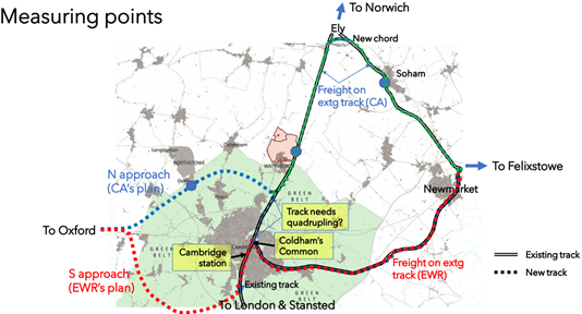
We have also, in some cases, used two measuring points to gain a more accurate assessment of the factors. EWR Co have consistently used only Cambridge station as the basis for comparison between approaches. This may be reasonable for passenger trains but for freight trains, Coldham’s Common is more appropriate since that is the point where freight trains from the two approaches diverge. A freight train is generally accepted to be noisier than an electrified passenger train and just because EWR Co. will not be operating the freight train themselves, it does not mean that the noise will not wake residents in the middle of the night. A map of the area is shown in Figure 1.
EWR Co have said that they have combined the two northern approach options (i.e. freight passing via a new chord just south of Ely and freight passing via a new chord on Coldham’s Common). They have, notably, omitted to mention any of the advantages of the former option in their comparison of factual data. In particular, there would be no impact of freight on Cambridge residents if our first option were adopted and much less overall. For clarity in comparison of numbers, we have used the Coldham’s Common chord option for measurements.
Results
Analysis
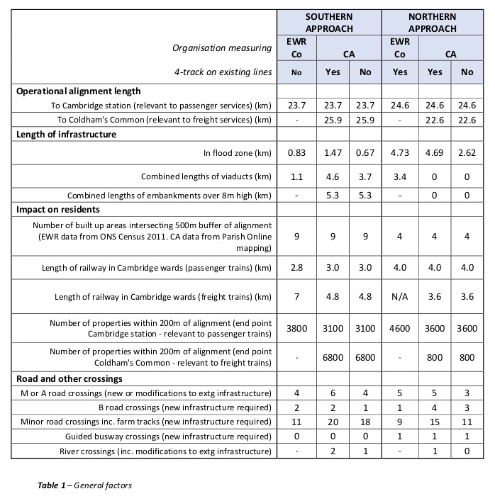
General factors
Operational length
EWR Co recognise that there is little difference (1.1km) between the track lengths of the two approaches for passenger trains measured to Cambridge station. However, the northern approach is over 3km shorter for freight using the Coldham’s Common chord.
Length of infrastructure
While the northern route passes through a greater length of flood zone, it plays this to its advantage by adoption of a trench solution which utilises the buoyancy effect in the waterlogged ground. This results in no viaducts and minimal embankments. It passes beneath roads and the guided busway and could be constructed while keeping the road traffic and guided buses operational. Oddly, when making the comparison, EWR Co have used a similar route to CBRR but, instead of using the CBRR trench construction methodology, they have taken an embankment solution and then proceeded to criticise it. The southern approach has a combined length of over 5km of embankment exceeding 8m in height. The trench approach has been presented on the CBRR website since 2018, so it is strange that EWR Co. do not even comment on it. Did they just miss it? Do they disagree with this widely used approach or are they just looking for reasons to justify a political decision made in favour of the southern approach and find this to be an inconvenient truth?
Impact on residents
This is one of the most important factors between a northern and southern approach, particularly in respect of noise. Night-time noise is clearly more problematic than day-time noise, so we believe that measures appropriate for freight services are more relevant than for passenger services. Although EWR Co have used a variety of assessments, including the length of railway in Cambridge wards, the most direct measure of this is the count of residential properties within 200m either side of the track. The length of track in Cambridge wards is not a very meaningful measurement because in some places the line passes through residential areas and in other places it does not. They have used Cambridge station as the basis for measurements: this is only appropriate for passenger services. We have also considered Coldham’s Common as a basis – see section above on ‘Assumptions and measuring points’. Our figures (which have been assessed by three separate people) are considerably less than those obtained by EWR. However, the absolute numbers are not critical for a comparison – it is the relative numbers between the northern and southern approach that matters. For passenger services the count is similar (slightly in favour of a southern approach) but the critical night-time freight measurement is massively in favour of a northern approach by a factor of over 8:1 (i.e. there are more than 8 times the number of residential properties within 200m of the track on a southern approach than a northern approach).
Roads and other crossings
The number of road and other crossings significantly impacts the overall construction cost of a railway. The greater the span of a bridge, the greater the cost so major road crossings affect the cost more than those for minor roads and farm-tracks. Assuming that 4-tracking will not be undertaken for whichever option is chosen, the overall result is in favour of a northern approach with slightly fewer A- and minor road crossings required. A more significant difference between the approaches is that because the northern approach would pass beneath existing roads, this would result in less temporary traffic disruption during construction and lower noise and visual impacts because of the trench technology.
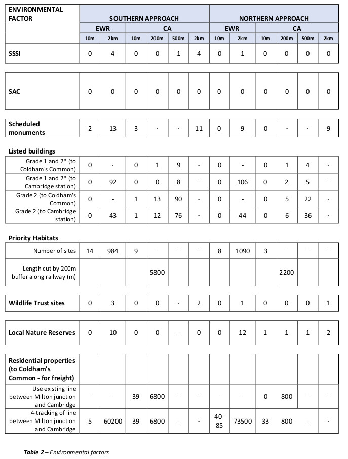
Environmental factors
Measuring distances to environmental sites cannot reveal the whole picture of the impact of the railway on a site. This would partly depend on the wildlife or ecology that the site is trying to protect. For example, the railway following a southern approach can cause a lot of damage to the Wimpole and Eversden Woods SAC but this is not revealed by the measure EWR Co use to show the impact. Although we have compared the approaches using the same measures as EWR Co, they still need to be considered with some degree of caution.
SSSIs
There are 4 SSSIs within a 2km buffer of the southern approach but none on the northern approach. EWR Co have mistakenly measured the northern approach as having 1 within this distance. The one they counted was probably Madingley Woods which is about 2.3km from the northern route.
SACs
There are no Special Areas of Conservation (SACs) within any of the buffers used by EWR Co. This does not demonstrate the impact of the Southern Approach on the SAC at Wimpole and Eversden Wood in which a colony of Barbastelle bats roost. The bats forage for around 5-7km from the roosting site and would not be affected by the Northern route. See our previous post on this subject, the Wimpole/Eversdens SAC is one of only Barbastelle SACs in the UK and it is in great danger from EWR Co.’s cavalier assertions about mitigation techniques that have failed in the past and would fail here again
Scheduled monuments
The southern route impacts directly (within about 10m) on 3 scheduled monuments whereas there would be no direct impact with a northern approach. Even using a 2km buffer, the southern route fares worse.
Listed buildings
As for other environmental counts, EWR Co have measured two distances from listed buildings to assess the impact of each approach: 10m and 2km, and only using Cambridge station as the measuring point. We consider this to be misleading and have counted listed buildings within three different bands, 10m, 200m and 500m for both passenger trains and freight trains. While EWR Co’s assessment shows broadly similar impacts of both approaches (with a slight disadvantage for the northern route for grade 1 & 2* buildings), our more nuanced and thorough evaluation shows a clear and significant advantage for a northern route, even when considering passenger trains. As mentioned earlier, using Coldham’s Common as a basis for assessment is appropriate for freight trains which cause by far the bulk of noise and air pollution impact on all types of residential property. On this basis, our figures demonstrate that there are more than double the number of grade 1 and 2* properties within 500m of the track on a southern route than on a northern route. The difference is even more stark for grade 2 properties with over 4 times the number within 500m.
Priority habitats
EWR Co have counted the number of priority habitats within 10m and 2km of the alignments. This presentation fails to take account of the size of each habitat. To address this omission, we have considered the length of a 200m zone passing through each site[WH1] , as shown schematically below.

Figure 2 Measurement of priority habitats
Although imperfect, it is considered more accurate than EWR Co’s measure. EWR Co’s assessment results in broadly similar outcomes. However, our measure shows the southern route has about a 2.5 times greater impact than the northern route.
Wildlife Trust sites
There is an advantage of the northern route over a southern route (1 site compared to 2 sites within 2km of the routes) but, because the total numbers are low and the 2km distance is great, this is not a differentiating measure.
Local Nature reserves
Our figures are much lower than EWR Co’s figures for both alternatives so it is likely we have not been able to access all the data that EWR Co have used. But taking EWR Co’s numbers at face value, there is a nominal difference slightly in favour of a southern option (12 sites for a northern approach and 10 sites for a southern approach). Again, this is not a differentiating measure.
Residential properties
EWR Co include commercial as well as residential properties in their assessment, whereas we have considered only residential properties. As previously mentioned, they have also assumed that the West Anglia Main Line (Cambridge to Ely line) will be 4-tracked but without providing any supporting evidence. We dispute this assumption and consider that it could be left as a twin track line. Putting this argument to one side, we have looked in detail at EWR Co’s figures. We count 33 residential properties within 10m of the line that could be impacted by a northern approach with 4 tracks between Milton and Cambridge. This compares to 39 for a southern approach. EWR Co, on the other hand, count 40-85 residential and commercial properties close to the line for a northern route and just 5 for a southern route. We have measured to the boundary of a property. While we do not correlate these figures directly with the requirement for demolition, we consider that EWR Co have made some errors in their assessment. For example, there would be about 11 properties that would be directly impacted on just one site at Highfields Caldecote (the Linden development) on a southern approach.
Conclusions
The overwhelming message from our analysis is that on the vast majority of measures, the northern approach is superior to the southern approach, including embankments, residential impact, road crossings and environmental aspects. For the remaining factors, there is a broad similarity between approaches. The measure that EWR Co have ‘afforded particular weight in the back-check undertaken’, the impacts on residential properties, is broadly similar in our assessment even using the doubtful assumption that the northern route will need some 4-tracking.
22 replies on “EWR’s ‘Comparison of Factual Data’ Tables”
Thank you again for all your hard work giving clear facts on the need for the route to go north.
May I ask whether Cambridge Approaches see themselves as representing people affected by either of the routes under debate. Eg. Is CA communicating with those who would be affected by the Northern option as well as those who would be affected by the Southern one. I just wonder how many people “in the North” support the option of the line going through their territory. Or do they have a different organisation representing their interests? I think such questions require careful attention or else the debate will be seen not as objective but as Nimby.
Thanks for your comment Jonathan.
I think the main point to remember is that the purpose of our campaign is for a fair consultation between a northern and southern approach into Cambridge.
We try to present the facts as we see them and, from our extensive investigation into the 2 options, we happen to believe that the advantages of a northern route outweigh those of a southern route. If a fair and rational consultation demonstrates that this is not the case, we would accept the democratic result.
The answer to your question is that CA are not communicating with those parishes who would be affected by the northern approach. A questionnaire in my parish of Elsworth shows overwhelming support for a southern route (though not necessarily the one EWR proposes) and for a station for Cambourne located south of the A428. We have a rudimentary network of parishes extremely concerned about the various proposals being put forward by EWR, CA, CBRR and Cambourne Town Council and the would-be developers of a new town, the misleadingly named ‘North Cambourne’, a settlement of at least 10k houses and possibly as many as 25k covering 640 hectares of greenfields. So it would not only be the impact of the line (embankments as in the south), but also of a major transport hub (freight sidings, etc) and the footfall of 30k people, all of which would devastate our environment and ecology. Where do you see mention of that by CA/CBRR?
It is so very important that the detail of the Northern option is not only clearly explained , but there is also a fact based compaison with the Southern proposal. The more I read, the more it appears that EWR have not been similarly thorough.
I don’t trust EWR Co for one second. Even if we obtain a full consultation on a northern route, I believe we need to have an independent assessment of the pros and cons otherwise I fear we will be bounced into the decision EWR wants all along.
I cannot see a mention of ancient monuments. Money Hill at Haslingfield is a Bronze Age Round Barrow dated approx. 1250 yrs BC and its’ associated ring ditch. There are a possible 5 other Round Barrows which have been levelled by ploughing. These have not been excavated to my knowledge. If the cutting or tunnel through Chapel Hill impacted these they would need to be excavated and the contents recorded. Please let us save this important archaeological site. The hill has been a lookout point over Cambridgeshire and the fens throughout the ancient history of Britain.
Thanks for your very pertinent comments Jennifer. We have generally used the ‘factors’ in EWR’s tables so have only taken Scheduled Monuments into account in relation to archaeology.
Great article …….
ZERO transport benefit to the people of Southern Approach Option E ……. POSITIVE transport benefit to the people of the NORTHERN APPROACH.
Compelling comparison of negative environmental impact data concluding NORTHERN APPROACH is the BEST CASE OPTION of an approach of a train services (passenger and freight) along the OXFORD CAMBRIDGE ARC.
EWR – You ask for feedback … WHY DON’T YOU LISTEN? Make the BEST CASE DECISION …… to quote yourselves “You said we listened”.
Positive benefit to the people of the northern approach? Has anyone bothered asking northerners what they think?
Thanks for your hard work. It would be desirable to carry out a cost-benefit analysis that monetizes the intangible distress caused to residents in addition to taking account of other tangible costs. Assuming that the Southern route affects 10 villages compared with the Northern route affecting 2 villages, the intangible costs of the Southern route would be hugely greater, and the benefit-to-cost ratio would be much less for the Northern route. However, I doubt very much if EWR will be influenced by logic or facts.
Thank you so much for this article and the hard work behind it. It would be impossible for many of us to put such lucid and measured statistics into a form recognisable to EWR. The main problem is how we face them with these evidences and solutions when they have already decided on the southern route.
Some points come to mind.
Firstly – comparing the northern route and the southern route is problematic. The northern route crosses parts of Cambridge and larger and newer villages whereas the southern route crosses a different part of Cambridge and the smaller and older villages. Larger conurbations will naturally have more resilience. A reduction of housing stock through compulsory purchase and demolition in the smaller villages combined with the potential closure of local roads and footpaths due to railway enclosures as well as the embankments will affect the services that can be economically provided:- primary school closure due too smaller attendance figures; bus services reduced or cut; shops closing through lesser trade to name just a few.
Secondly – the proposed development of the integrated metro, bus-way and greenway routes. I understood the overall plan was to relieve road congestion and pollution in and around Cambridge. The integrated system will need to efficiently link the “Cambridge suburbs” with the various work, business, hospitality, health, commercial and leisure centres as well as to the BR stations and the Park & Ride system.
The centre of Cambridge is largely shops, hospitality and leisure venues and colleges.
Research, development and business parks are largely on the periphery of Cambridge where more land for development is available. Visitors from Oxford are more likely to travel to these parks, typically the Wellcome Genome campus; the science and business parks clustered about Histon, Milton and Melbourn; the pharmaceutical companies on the Addenbrookes and Royal Papworth site; etc. to name a few.
Is EWR to be part of the integrated system? If so, EWR only needs to stop at one station (say North Cambourne) to link into the integrated metro system. In fact, a new station further to the north of Cambridge could be established and no additional freight trains would need to pass through Cambridge or south Cambridge!
You make some good points. The post was intended to rebut EWR Co’s so called ‘factual data’ and the nuanced issues you raise would be difficult to address in numerical terms alone.
There’s a lack of clarity or consistency in which freight routes were used in different parts of this analysis. For example, in “Operational length”, freight is routed via the Newmarket line, whereas the map and other sections show or imply freight routed via Ely (on what appears to be a much longer route).
I’m not sure that including properties adjacent or near existing railways is entirely justified, as these residents will be accustomed to the impact of train movements and thus a few additional trains will not have the same impact as with a whole new line. I would suggest splitting these figures into two: residental properties near proposed lines, and those near existing lines.
I would also suggest justifying the assertion that the line north of Cambridge would not require 4-tracking. Perhaps link to whatever modelling or other data you have here?
I am unconvinced that measuring the length of affected SSSIs (etc.) is more “accurate” than counting them. I don’t think the value of an SSSI correlates with its size. Can you provide some justification for this methodology?
Thanks for your comments David.
1. We have used the Coldham’s Common chord for measurements (see last sentence of last paragraph of ‘Assumptions and measurement points’)
2. People who live next to existing railway lines would be accustomed to noise from almost exclusively passenger trains during the day. However, they would not be accustomed to the anticipated volume of freight trains both during the day and probably at night. This would be an order of magnitude higher impact.
3. As mentioned, we plan to publish a new post on this shortly.
4. For priority habitats, it is likely (though not certain) that larger areas will contain greater numbers and greater variety of species. The post acknowledges that even this is not perfect but we consider it to be a more rational than purely counting numbers. The logic has only been applied to priority habitats and not to SSSIs.
Brilliant work as always.
If you can convincingly eliminate the need for for the four tracking on the northern route it would be massively preferable to the southern route.
Would it be possible to get Northstowe Town Council (if there is one) to ask EWR to be on the route and be provided with a station?
Cambridge Approaches is trying to contact Northstowe Town Council. We’ll post an update on our website if something positive comes out of it.
I remember clearly the initial consultation at Orwell village hall when the 5 tables were set out, and asking the callow youth on table 5 where was the CBRR table? I found them outside the front door of the hall sheltering from the rain having been excluded. What sort of “consultation”was this? Of course the majority of respondents called for a route through Cambourne but they were never given a choice after that? ERW are still peddling this consultation as evidence of a preference for the southern route when all it was is a preference for Option E over the other options that EWR were touting.
Excellent analysis as always David. I have a couple of comments:
1) Parishes north of the A428 are just waking up to the prospect of a station north of Cambourne and are not at all happy about that. North of Cambourne is outside EWR option E so this may be a good reason for EWR having to go back to a full public consultation if a station is to be built there. Certaining the folks I have talked to on that side don’t want a northern EWR route. Cancel EWR?
2) A cord through Coldham Common could be an issue. Coldham Common is protected in law and could potetially require an act of Parliament to gain permission to add a line.
3) I agree with the 4 track vs 2 track argument. If 4 tracks are required for a northern run into Cambridge, why are 2 tracks sufficient through Harston? Surely there are more trains going south-west to London than north to Ely? Does anyone have a comparison count?
4) Not completely true that a southern approach has no local benefit. It could remove cars off the road that rat-run through the villages….at least until the A428 is connected to the M11 at Girton. Also some of us have connections in Oxford and would use the train!
5) I also thought that terminating in Cambourne could be a good option with light rail, tram, metro, bus links into Cambridge and the surrounding area. It is a pity that people in the south voted against James Palmer as it now looks as if the CAM idea will be scrapped. Fast underground links through Cambridge from all directions would be a far better solution than adding more buses to already crowded roads. (Just my opinion!)
6) My feeling is that EWR intention has always been to link Oxford to Cambridge south station. This is the only conclusion I can come to. After all the station supports 20,000 jobs! (….according to EWR webinar)
7) I know people don’t like the idea of embankments. My fear is that an on-grade track (ground level) would result in all footpaths, permissive routes, bridleways being cut. At least it is easier to have tunnels through embankments to keep these open. We need to keep these connections open no matter what.
The Mullard Radio Astronomy Observatory is an important scientific site, where pulsars were discovered. The M11 traffic is radio-noisy and was located well away from the radio telescopes. The motorway is lower, and carefully shielded from the Observatory by a steel fence. The Southern Approach skims the end of the Observatory, and the passing trains will presumably cause a lot of radio noise. This will need tall shielding. Has the need to shield the trains from the radio astronomy been considered in the analysis?