We made an initial assessment of the Great Wall in our previous post on the subject. We have now had time to look at the proposal in a bit more detail and this post presents more of our analysis.
Height Profile and Distribution
The structure we describe varies in height along its length and also switches between being an embankment, a viaduct and a cutting. EWR Co. are picking statistics about The Great Wall which may make it seem smaller than it actually is. For example, some of it is at ground level (not much, but some). As it is not one continuous type of structure, the length of each individual section of embankment, viaduct or cutting obviously has a limited length. But one thing is clear: the length of the entire structure from Cambourne North Station to Hauxton junction is 17.4km. As you enter a cutting from an embankment, yes there will be a point where the level difference between the track and the local ground level is zero.
We prefer to present the data in a form that makes it easier to understand.

Figure 2 shows the height above local ground level in metres versus the distance along the track or “chainage” starting at EWRCo.’s proposed Cambourne North Station and ending at their proposed Hauxton Junction. The height is above 4m for 12 km out of the 17.4km from Cambourne north to Hauxton Junction. But the line is particularly high near houses in Highfields Caldecote, Little Eversden, Harlton, the two approaches to Haslingfield and wrapped around the south and east of Harston.

Figure 3 shows the distribution of heights of the structure above local ground level. Specifically, it shows the length of track above a threshold level. For example, looking at figure 3, there would be just over 6km above a height of 8m.
Leaving out any overhead line equipment, trains are around 4m high. So, with a 4m high embankment or viaduct, it would be possible to see the top of a train above the 8m rooftop of a 2-storey house.
Embankment Cross Section
CBRR have produced a cross-section of what a 10-metre high embankment would look like (see Figure 4).

The tracks are on a 10m wide platform. To reduce noise impact, we would expect acoustic barriers on either side of the track. If we are lucky enough to get an electrified line then the Overhead Line Equipment (OLE) would be on top. Remember also that in most of this section the trains will be travelling at up to 100 mph.
Either side there would be slopes, usually at an incline of 1:3, making the width of a 10m high embankment 70m. These slopes would be too steep to be returned to farming. There would be security fences on either side of the embankment and culverts every so often to allow the passage of wildlife and people.
Consider the school children making their way to Comberton Village College from The Eversdens. Will they divert and cycle down the busy A603? Will they pass through a 70m culvert on dark December afternoons? Will they get through the security fence and cross the tracks? There could be similar issues for young children from Newton to Harston primary school or from Harlton to Haslingfield primary school if there is no safe way to get across the Great Wall.
Much of the route will be on clay and a significant foundation will be necessary with piles beneath it to reduce settlement as shown in Figure 4. Consider the carbon emissions required to make these large structures and carry in the material to do so. The material from the destruction of Chapel and Money hills will not be enough.
Land Take
We have estimated that the total area of land required in this 17.4km section, taking viaducts to be just 10m wide and embankments and cuttings with 1:3 slopes. The width of the embankments can be calculated from their height profile and a 3m width allowance for security fences on either side. The result is an estimated 206.3 acres of land taken by this structure excluding any construction or maintenance roads on either side.
It would be interesting to get an estimate of the weight of material that would need to be transported to make these embankments.
As previously explained the farmland to the south of Cambridge is particularly important for food security when climate change induced sea level rises are considered. The author of that article has estimated that 44.5 acres of his land near Harlton will either be directly lost or become unfarmable – and that is just one farm. The effective land take is likely to be much-much higher than 206 acres. This is farmland that has been cultivated for generation after generation.
Before you reach the conclusion that it would be the same to the north – please consider the trench railway technology proposed by CBRR for the fen-crossing section of their proposal and their proposal is low in the landscape all the way from Cambourne North station into Cambridge.
Viaducts
We can get an idea of what a modern railway viaduct will look like from the recently constructed Hitchin Flyover (See figure 5). But bear in mind this is only 5m high and single track.

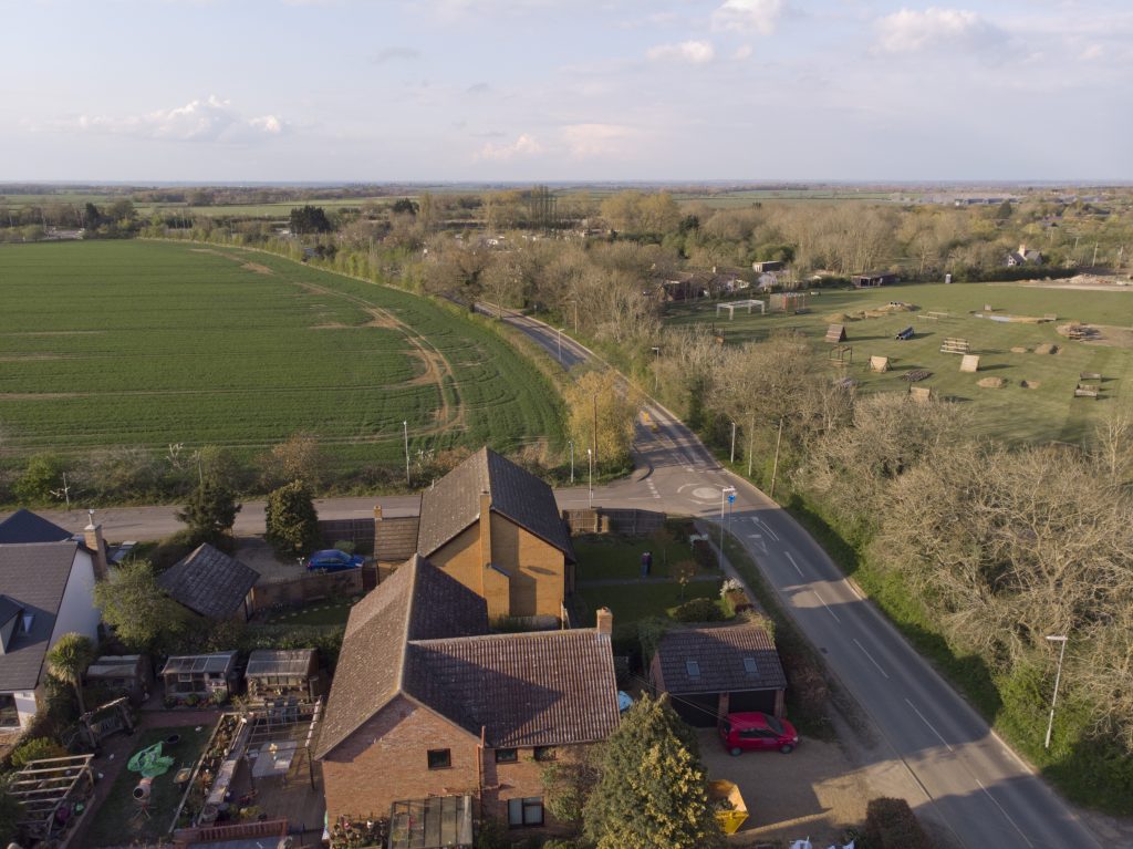
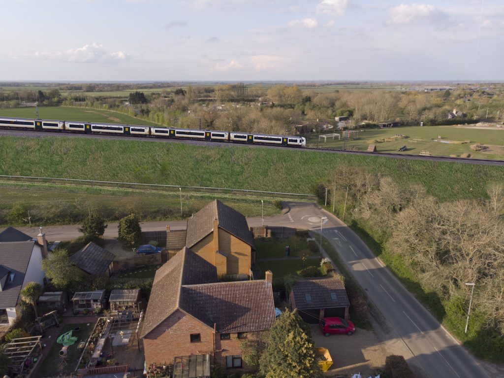
Composite Photograph of Highfields Caldecote


An Impression of the Environmental Impact
This post has so far focussed on the facts about the proposed Great Wall. We shared something about how we feel about it here and here.
Local residents Anna and Tom have prepared a video entitled “Muted By Covid” which shows part of the section of the proposed route between Harlton and Haslingfield on the ground.
13 replies on “The Great Wall – Part 2”
People don’t like high embankments and the increased train noise. How do barbastelle bats feel about them?
Good work – that makes you question why it is cheaper to come south where the ground undulates so – apart from being far more visible and impactful from the surrounding area.
Where are they going to get all the material they need to build the embankments? I don’t suppose it will all come out of Chapel Hill?
Thank you for the aerial view of our house showing before and after!
We have received many phone calls from concerned friends, adding to our anxiety.
This proposal is beyond comprehension. Who would plan to route an enormous busy freight train through our historic City. The first principle must be to avoid the City but have a station close to the recently widened A14, to allow connectivity N, S, E or West, ie the Northern route. The same applies to passengers. Passenger connectivity to The Science Park, Addenbrookes and City is a separate issue and resolved using local, not National initiatives. Their naivety will become obvious when they have to admit their decision to use diesel was also stupid.
I have completed the required fields ie name and Email
Please advise if I still need to act on this. Thanks. John Holmes
Thank you so much for translating the data given by EWR into the readily comprehensible, but terrifying, information in Figures 2 and 3. That is a huge help to us all. The link to the inevitable loss of invaluable ‘breadbasket’ farmland adds to the punch of this post.
Thankyou, Anna Todd and Tom Lindley for your excellent short but succinct and poignant video on the impact of this proposed route.
Please everybody share, share, share…
The southern approach to Cambridge is very open, flat and subject to strong winds.
Last Thursday (29th April) Olivia Rudgard reported in the Daily Telegraph, a study from King’s College London entitled “Pollution is as harmful as lead poisoning for children”.
The pollution (Nitrogen dioxide and particulates) produced by a heavily loaded diesel freight train travelling on top of a high embankment will spread widely. None of the inhabitants of the southern villages or south Cambridge will be safe from the effect of this pollution. Neither will the farmland nor water courses.
I trust EWR have considered the health and well being of this population and will publish the pollution foot print of the proposed route before the end of the current consultation period.
I note from the embankment cross section, the acoustic barrier is just to one side.
The open nature of the southern approach to Cambridge would require a barrier on both sides to stop the noise pollution affecting the villages and south Cambridge.
The height of the “great wall” would be 4 m or more higher than indicated in figure 2.
Being concerned about the effect of the southern route into Cambridge and about its impact on Haslingfield in particular, as an amateur artist, but not an engineer, I drew a map to envisage the impact of chalk embankments on the landscape given they take a long time to go green. It also occurred to me that the existing line into Barrington quarry could be used to shorten the tunnel and reduce the impact of the line on Chapel Hill.
I will email a copy of this map to William Harrold who recently gave a talk on E-W Rail to the Trumpington Meadows Community for me.
Please use the sketch I sent to William if it is of any help
Thank you for translating the ewr info into a more understandable form and creating the visual pictures so NOONE can be in any doubt as to the HUGE impact the southern approach would have on us all. What is are MP , city, district and county council doing to block this massively controversial southern route. Who in power is standing up to ewr for us, us being the many many people of the villages effected by the proposal ?
The pollution and noise levels would be highly detrimental to these villages on the southern approach scheme not to mention gross health concerns . Defacing the countryside AND causing grave respiratory health concerns . Does it make sense NO NO NO .