Introduction
The EWR Co. 2021 non-statutory consultation includes a policy statement[1] on noise and vibration in which we find the following statement. “Sometimes we will need to elevate the track, for instance when trains intersect with roads and cross land in a floodplain. However, where it’s practicable we will consider building the track low in the landscape. This can help reduce noise and has the benefit of reducing the impact on the landscape.”
Although they recognise that it is good to build low in the landscape (and as we shall see, this is good for several more reasons than just noise and vibration), the circumstances where they elevate the railway occur frequently. This has resulted in proposals for the approaches to Cambridge, north or south, which can only be described as a desecration of the landscape in our precious green belt. Indeed, it is hard to overstate the hideous nature of the proposals that we have before us.
This post has been written with the guidance of experienced civil engineers and the hope is to help EWRCo. find a better solution. But it is also to explain to others what is possible and is achieved elsewhere in the world and so to set all our expectations a lot higher. CBRR have, as volunteers, looked at a low impact railway design for the northern approach, but have not done so for the southern approach.
But before we get into all that, we start with some important background.
Background: Number of Houses in Cambridgeshire to Double by 2050
The EWR project forms part of Whitehall’s OxCam ARC initiative as set out in their National Infrastructure Commission (NIC) report[2] and confirmed in the recent OxCam Spatial Framework 2021 from the Ministry of Housing, Communities and Local Government (MHCLG)[3]. The NIC report (p.28) envisages building 1 million homes in the Arc between now and 2050 and in particular 271,000 in an area approximating to Cambridgeshire.
Since the area in the NIC report is not the same as the county of Cambridgeshire the percentage increase between the baseline date of 2014 and 2050 is harder to estimate from publicly available figures, however and Oxford Professor David Rogers has stated that it represents an 81% increase. The recent rate of housing growth will soon have to double to make that target by 2050.
The average home in the UK generates over 50 tonnes of CO2 in construction and emits a further 2.7 tonnes per year[4]. That’s 26.7 million tonnes of CO2 between 2014 and 2050 for construction and a rate of emission of 0.73 million tonnes / year after 2050 excluding any further construction. We cannot go on like this.
The population of the UK is forecast to grow by 16% by 2050 with the addition of 3 million homes. Therefore, the 1 million homes in the Arc is one third of the number for the whole UK and is concentrated in just 4.7% of the UK’s land area. The NIC report refers to this “transformational” growth, way beyond anything needed to serve existing residents. We will be transformed into an urban sprawl from Oxford to Cambridge – see Figure 1. Who does this benefit? Not local residents. I suggest that local politicians consider who they are elected to represent. We do not want this.
The OxCam Arc plan is for Cambridgeshire to grow much, much faster than the UK average. The OxCam Spatial Framework plans to create 1.1 million new jobs. We are talking about a lot of people moving into the area. Everyone should be interested in the environmental impact of this and we recommend watching the talk given to the Friends of the Cam recently by the Oxford Professor of Ecology David Rogers who provided many of the insights above.[5]
Our local environment and residents are in for some cruel and unusual punishment if the OxCam Arc goes ahead and EWR Co.’s project is a core part of it.
Yes, we need more houses and we need better transport for local commuters, but the plans for the OxCam Arc go way beyond that. Perhaps Whitehall have the scene in Figure 1 in mind for the whole OxCam Arc and Cambridge in particular. How long will even the green belt last?
Incidentally, how can anyone plan, propose, decide or even comment on the route of the railway when there is no plan for where these 271,000 additional houses are to be built?
Why talk about this in the context of a post about ‘low Impact design for railways’? Well, most of the Cambridge Approaches material is working on the premise that the EWR Central Section does have a sensible triple (profit, people, planet) bottom line case and, given that it will be built, we are looking at where might be the most sensible place for it to go based on available information. Put another way, we are addressing the proposition in front of us. However, we will just make two points.
- If there is a business case for the Bedford to Cambridge section it will be predicated on this massive housing growth and EWR Co. are therefore in no position at all to take the any moral high ground on CO2 emissions.
- To encourage all these people to want to work in the area the railway needs to be attractive as specified in the Sponsors Requirements[6]. The Great Wall, huge grade separated junctions and lots of 4-tracking in Cambridge are an appalling start on this.
Railway Engineering Structures – A Survey of the Options for Low Impact Design
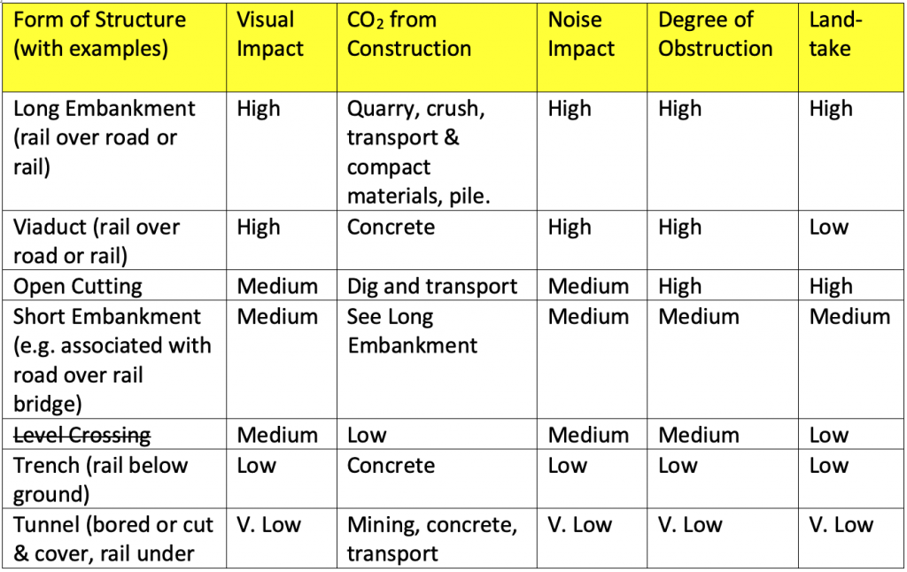
Level crossings are no longer being built for safety reasons, so we are left with some of the more difficult choices in Table 1 above. EWR Co. have proposed a route involving long embankments, viaducts and rail-over-rail grade-separated junctions as part of the extensive 4-tracking as the new railway approaches Cambridge from the south or the north. As can be seen from Table 1, these are some of the structures with the most adverse impact from an environmental point of view. So why are EWR Co. proposing them?
EWR Co. have expressed concern about crossing flood plains and cite a recent landslide in Scotland as a reason to avoid them where possible. We assume that they are talking about the Stonehaven derailment in Aberdeenshire.[7] This occurred in severe weather near a river crossing in quite hilly terrain where the land slipped. Landslips are often triggered by inadequately maintained drains. The flood plains to the north and south of Cambridge are in flat terrain and there are no river crossings on the northern approach proposed by CBRR. So, we fail to see the relevance of this incident to the Cambridge approaches. It would perhaps be more relevant to the Cam-crossing south of Harston as EWR Co.’s proposed route emerges from Chapel Hill and crosses the river on a high viaduct and embankment.
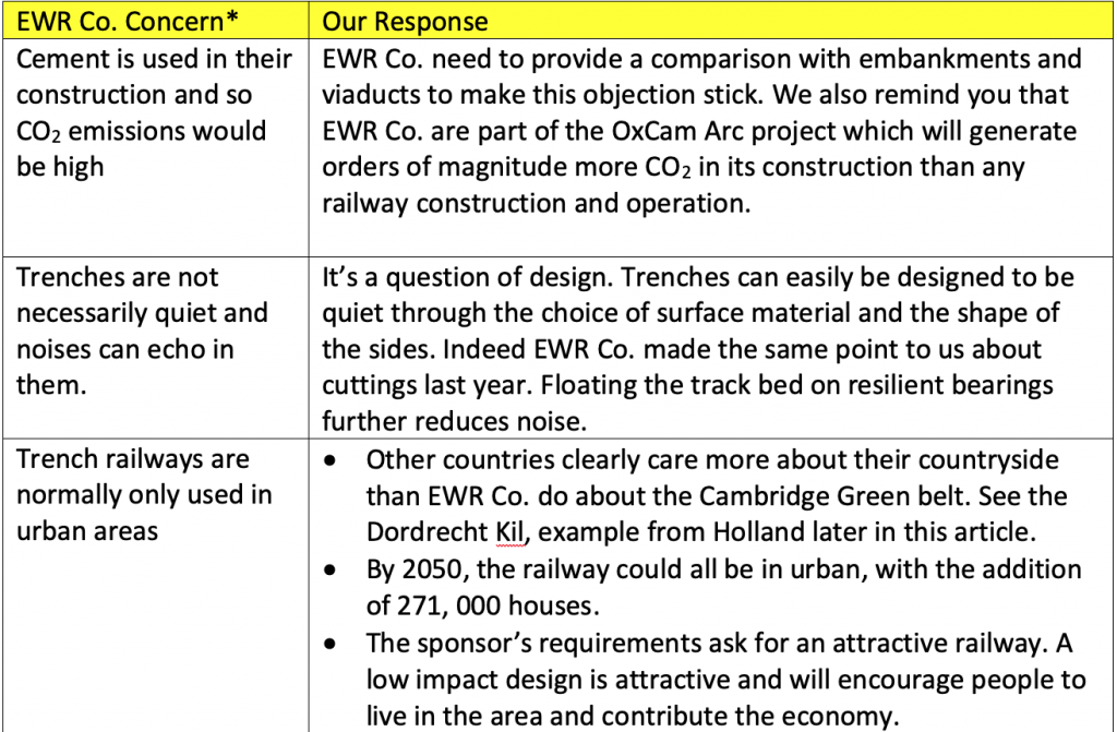
Towards the bottom of Table 1 we see trench railways as a low impact solution. However, EWR Co. have concerns about these. We address their concerns in Table 2.
EWR Co.’s Analysis of the Northern Approach
EWR Co. flag that “A northern route would cross the newly upgraded A14 trunk road to the west of Girton, which at this location is an eight-lane dual carriageway. This would therefore require a substantial bridge structure. The prevailing low-lying land level mean that this structure would be a prominent feature in the surrounding landscape” see Technical Report Appendix F §1.1.4.
In §1.1.5 of the same report they go on to say: “An additional station could be provided at Northstowe, but the area is low-lying and forms part of a floodplain so the station and its approaches would necessarily be elevated. A junction with the existing West Anglian Main Line (WAML) would be located north of Milton and this too sits in a floodplain.”
As previously discussed they immediately assume that rail goes over road and flood plains need embankments. CBRR’s hugely experienced consulting engineers do not make any such assumptions.
CBRR’s Fen Crossing Proposal for the Northern Approach
In 2018, CBRR published some preliminary alignment notes for CBRR’s proposed route. After discussion with EWR Co. during 2018, CBRR revised their notes[8]. The route proposal included a Fen Crossing section involving a trench railway so that, where necessary, the railway can have low impact as set out in Table 1.
To quote from their notes. For Map 6 “The highest ground along the route is north of Bourn Airfield where it is about +70mOD, and the line will need a cutting to limit the height to +65m. East of the station it leaves the A421/A428 alignment and drops steadily while heading north east to the east of Dry Drayton and passing below the A14 near the Cambridge Crematorium. By crossing below the A14 the impact on the crematorium will be reduced.”
For Maps 7 & 8 we find the following notes: “North-east of the A14 the line passes to the south-east of Oakington, where a station is proposed to serve Oakington and Northstowe. It then has to cross the fens for about 9km before joining the Cambridge – Ely line. For the fen crossing it is proposed to once again lower the alignment to below existing ground level and contain the line in a structural trench with walls up to flood protection level. This allows it to pass below the Oakington – Girton road, the guided busway, B1049 north of Histon, Landbeach road, and the A10 north of Milton. The advantages of keeping the line low are the reduced visual impact, the ease of building over-bridges, and the avoidance of new embankments which would cause continuing settlement for years after construction.”
EWR Co. have clearly missed the option of rail under road and trench railways in their write up of the northern approach, but they do follow the same route as CBRR in their analysis of the northern approach[9]. They have also completely missed it for the southern approach. In terms of structures the only options they consider are embankments, viaducts and overbridges. They then conclude, correctly, that these have higher visual impact as we have said in Table 1.
It seems that EWR Co.’s analysis has missed an opportunity to reduce the environmental impact of the railway and this has led them to produce hideous proposals for approaches both northern and southern. One of their reasons to reject the northern approach is the hideous nature of their own design. This is completely invalid.
To get an initial impression of what the design of a trench railway would look like in context it is perhaps best to look at this fly-through of an Oakington / Northstowe Station as proposed by CBRR.
Notice that right at the end of the video, it is practically impossible to see any evidence of the station. This fly-through has been created by a local game designer based on engineering drawings from CBRR.
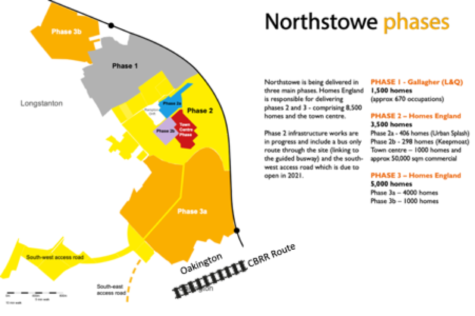
Northstowe Station
EWR Co., misleadingly, describe the access to the proposed Northstowe station as follows: “The proposed station at Oakington for Northstowe is at the very southern end of the new town, south of Oakington village, nearly 5km away from the northern edge of Northstowe (roughly a one hour walk).”
It is also worth seeing this in the context of Homes England’s plans for Northstowe when fully built out as we assume it would be when the EWR services would start in 2030 (see Figure 2). We agree with EWR that the current settlement of Northstowe is some way from Oakington, but this rather misses the point that only 7% of the housing has currently been completed and that happens to be at the other end of the new town (Phase 1 in Figure 2). When fully built with phase 2 and phase 3, it will reach all the way to Oakington. We also point out that there are other ways to travel 5km than walking. Why don’t EWR Co. say this?
Although the Sponsors requirements ask for a commuter railway and the EWR Co. traffic model says that 70% of journeys will be local, EWR Co. are proposing a solution which will serve very few people in the area at least initially. It’s for people that live in Cambourne and happen to work at the Biomedical Campus or central Cambridge. How many is that? There are other ways to meet that demand.
EWR Co. also point out that that Northstowe already has the guided busway and imply that it does not need any more public transport provision.
Note that the busway shown in Figure 2 has two stops. During a visit on the 11th May 2021 we found this sign (see Figure 3) at the Longstanton stop to the north of the plan in Figure 2 and repeated on the front of the buses. Passenger numbers are reduced due to the pandemic and some social distancing is required on the buses, but Stagecoach are using all their buses and there is a currently a capacity shortage. We understand from bus users that the Cambridge buses are already full before they get to the Longstanton stop and this has been the case for years.
We then visited the Oakington stop at around 11am the first Cambridge-bound bus to arrive displayed a “bus full” sign and did not stop. Here is a video of it passing through. Also we could only find two car parking spaces at Oakington Station.
EWR Co. may have spoken to Cambridgeshire County Council about future plans for the busway, but they should realise that these plans are now the responsibility of the Mayor of the Peterborough and Cambridgeshire Combined Authority not of the County Council. Why don’t EWR Co. know this? Furthermore, the new Mayor has dropped the Cambridge Autonomous Metro. This means that the roadmap for the busway is in a state of flux.
What will the situation be like in 2050 if 271,000 more houses have been built in the Cambridgeshire area?
CBRR Trench Design
CBRR are proposing a particular design for their structural trench which makes it suitable for use in low lying areas in flood plains. Figure 4 shows a cross-section of this trench.
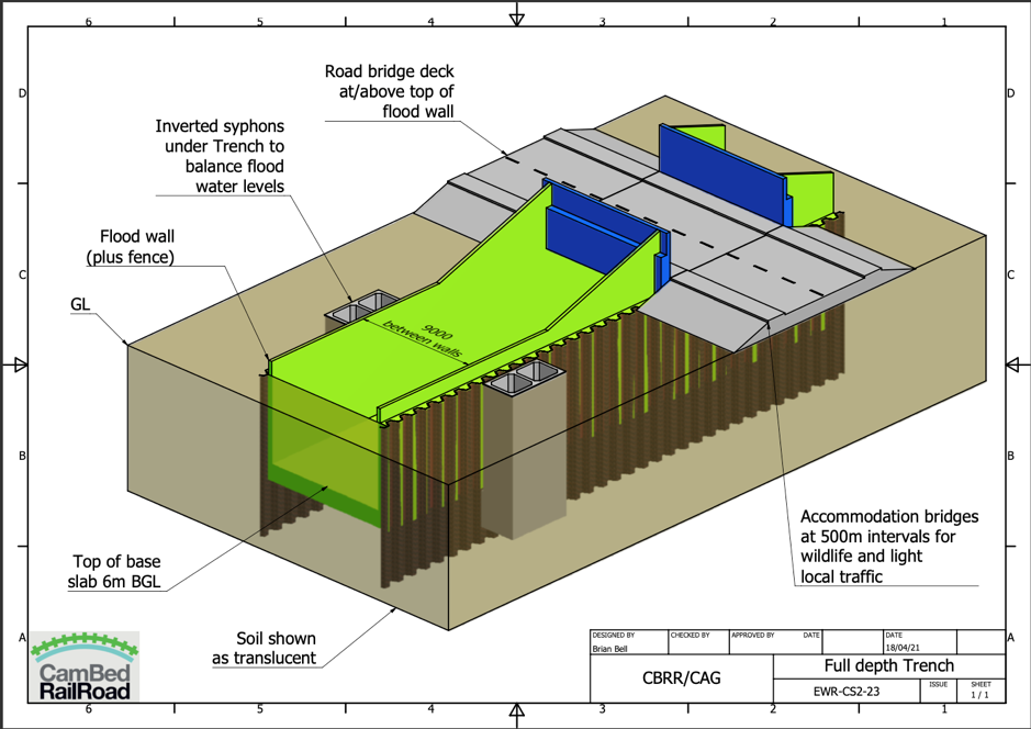
The main features are as follows:
- Trains run in a trench of neutral buoyancy so most of the time it neither tries to float or sink
- Flood walls on either side
- Inverted siphons to allow any flood waters to pass beneath the railway line
- ‘Green’ crossings about every 500m for any roads, PROWs or agricultural access
Trench Railways around the world
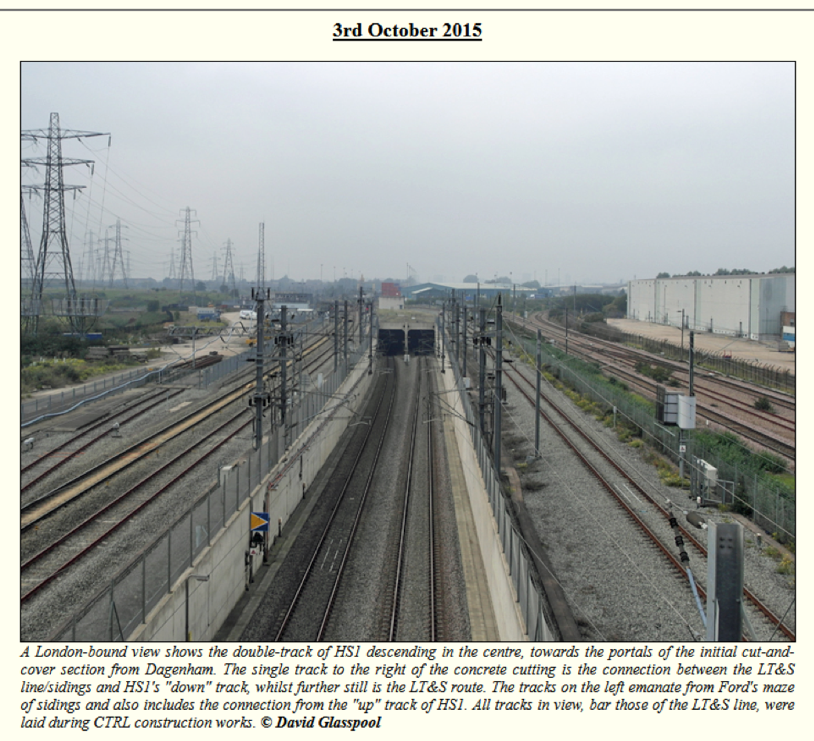
The designers of the CBRR proposal used a similar approach for the design of a section of the HS1 link near Dagenham which has since been implemented (see Figure 5)
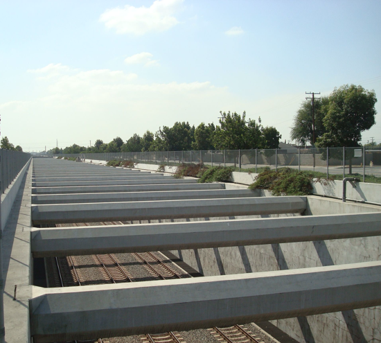
The technique is used for the San Gabriel railway near Los Angeles in a place where there is an earthquake risk and where it won a Californian design award in 2019 (see Figure 6). The currently proposed central section of East West Railway does not look like it is about to win a design award.
The high-speed line between Brussels and Amsterdam also uses the same idea (see Figure 7). See for example this stretch on the approaches to a tidal river called Dordrecht Kil. As with the CBRR approach, the railway goes underneath. Note the water in the ditches on either side of the line – this is a really low-lying area. Dutch engineers know a thing or two about working in flood plains. EWR Co. imply that the precious green belt approaches to Cambridge do not warrant such a low impact design. Perhaps in Holland the government values the environment more than EWR Co. appear to.
Comparison of a Trench and an Embankment
In our previous post relating to the embankments of EWR Co.’s proposed Great Wall, we described the likely dimensions of such structures.
It is perhaps worth comparing the scale of the two side by side to show their cross sections.
This is shown in Figure 8 above. The trench is narrow, reducing land-take and facilitating crossings. It is also deep enough to hide the 4m high trains and any overhead line equipment. The embankment is just the opposite, and may even be worse if it needs a noise barrier on top.
We talked about land-take in our earlier post about farming, but these embankments would be much worse due to the direct land-take and the difficulty of getting across them. We have spoken a local farmer who told us that his family had worked and developed their farm for 5 generations, but if this happened, it would all be over.
Other farmers have been estimating the effective loss of farm land due to uneconomically sized and shaped plots left by cutting fields indiscriminately. The land that would fall directly under the embankments are a small part of the total lost. The ease of crossing trenches is really important to farming.
Conclusion
We have set out a variety of railway structures and ranked them in order of their impact from high to low. EWR Co. have proposed using high impact techniques for both their southern and northern approaches through the Cambridge green belt as though there was no alternative and to hideous effect.
During the current consultation, EWR Co. have objected to the use of low impact railway designs at all on the grounds of CO2 emissions associated with their construction. They have not compared it with their own high impact proposals on those grounds. Nor have they even mentioned them in their analysis despite them having been published by CBRR for use where necessary and for all to see in 2018.
Their comments seem to indicate a disrespect for the environment and for local residents. This is a shame on multiple levels, not least since we presume that one of the objectives of the OxCam Arc is to create an area will people will actually want to live.
The fact that EWR Co. CEO Simon Blanchflower speaking on Radio Cambridgeshire recently said that he would not want the railway coming near the village where he lives, speaks volumes. It can be compared to the moment in 1992 when Gerald Ratner described one of his companies’ jewellery products as ‘crap’. This led to severe damage to Ratners’ business. But what will happen to the state-owned monopoly EWR Co.? How unpopular do their proposals have to be to have any effect?
We have presented some background to set the railway construction in the context of the OxCam Arc and its toxic assumption that a million homes will be constructed by 2050. This is so that the attempt by EWR Co. to take the moral high ground on climate change can be seen in context. If there is a case for the EWR, it is as part of the OxCam Arc with all that that entails.
CBRR’s experienced engineers have shown how where necessary, low impact design techniques can be applied to the northern approach. Although not described in this article a lot more could be done with a southern approach to reduce the impact with trenches, tunnels and putting the railway under roads, railways and rivers. The CBRR design sets the standard that we want to see in the green belt of Cambridge.
[1] Our approach to Mitigating the Impact of Noise and Vibration in Local Communities, Section entitled Low-impact route alignment.
[2] “Partnering for Prosperity”, NIC Report 2018.
[3] Planning for Sustainable Growth in the Oxford Cambridge Arc: An introduction to the Oxford-Cambridge Arc Spatial FrameworkFebruary 2021
[4] What is the carbon footprint of a house?
[5] The Oxford-Cambridge Arc; An Environmental Catastrophe – Professor David Rogers. 30 April 2021
[6] Making Meaningful Connections Technical Report Appendix A §1.2
[7] Stonehaven Derailment August 2020
[8] CBRR Preliminary Alignment Notes May 2018, revised Sept 2018
[9] Making Meaningful Connections, Technical Report Appendix F
4 replies on “In Search of a Low Impact Design for the Cambridge Approaches”
Without some of the mitigations outlined in this excellent overview which EWR must consider , our environment will suffer irrevocable destruction and unrecognisable change. Knowledge is power. Knowledge shared is power multiplied. Thank you Cambridge Approaches and CBBR for sharing this expertise and campaigning for the best interests of local communities.
Excellent article. Economists and environmentalists have been saying for decades that an agenda of endless growth and “build build build” is a catastrophic fantasy. It’s time we turned away from a mentality that says “We’ll put 300,000 houses here and offset the damage elsewhere” and toward a mentality that says we will restore and regenerate nature first and then fit needed development around that. This will force us to avoid over-development of certain areas for profit while other areas which need investment are ignored. This government’s new proposed planning legislation which makes it easier for developers to build in rural areas must also be resisted. Our next (June) show on The 7th Generation on Cambridge105 radio includes an interview with David Rogers.
What an amazing study. It just shows how important it is to draw on local expertise and local knowledge. It demonstrates how inadequate our government departments are. Time for a new approach.
EWR Co has been commissioned by the DfT to build this line. But have the design requirements been made public? How many trains a day, of what types? How much freight? How much commuter traffic, from where to where? How much express passenger traffic, from where to where? How can EWR design a line if they don’t know what it is FOR??
Surely such a specification is the first thing any engineer would require before taking on such a commission. Time to let everyone know what the aim is ….