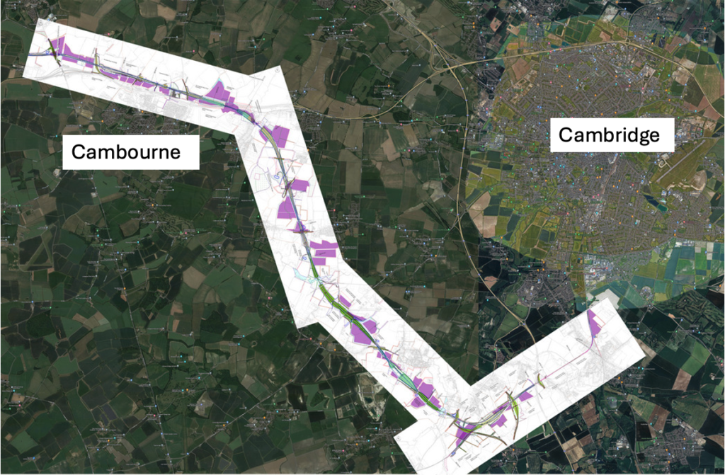
Here are two more accessible versions of the four Arup maps we published in our previous post.
Firstly, for orientation here is a low resolution composite of all four maps together on top of the Google satellite image for the area (many thanks to our map expert Leigh for this).

Secondly, a downloadable a high resolution version of the same map which can be downloaded. It is a 207.5MB file so be patient. Apologies our web server is not up to viewing this on line. After downing the .png file you should be able to zoom in to areas of interest and go back to the maps in the previous post for the key.
The overall picture is a 500 metre wide strip of land 50km long from Hauxton south of Cambridge to Clapham north of Bedford. And then there are the new towns at Cambourne north 53,400 people (Cambourne increases in size by a factor of 6.8*) and Tempsford 44,000 people, bit of these sites will also need biodiversity net gain. The land take is colossal.
How we got the maps and what has happened since they were published.
It took 3 years and multiple legal appeals for Cambridge Approaches (and Leigh Day, and our local MP’s office) to get EWRCo. to release these maps which show the scheme in a level of detail we have not seen before – including the land take for construction and biodiversity net gain (BNG). Oxford Prof. David Rogers confirmed to me that construction land cannot be used for BNG, since that must start from day one of the construction. Consequently BNG land would be compulsory purchased along with the land for the railway. Refer to the previous post for the key to these maps.
Of course, EWRCo. will have been working on these plans since January 2022 when the versions here were completed. One naturally expects to see this level of detail in a planning application for a new house or extension in order to be able to comment on it. Why is it so difficult to get EWRCo. to do the same?
Suspension of Farm Business Interviews
In the same way as some of the thousands of affected home owners between Bedford and Cambridge were sent Land Information Questionnaires, farmers are being offered Farm Business Interviews (FBIs). These interviews (I attended one) are again to collect information but they are much more useful from the farmers’ perspective if they can see the details of the proposal – even if it is out of date. In the light of these maps, another farmer (who wishes to remain anonymous) came forward and said to EWRCo.’s agents that he would, after all, like to have an FBI. Here is the response he received from the EWRCo. representative:
“Many thanks for your e mail and no need to apologies (sic) for the delay in responding.
We are accompanied by another person for the FBI meetings, but only as there is a ‘no lone working’ policy in place at EWR. The other person in attendance is from Ardent who are undertaking the land referencing on behalf of EWR, and, being the company involved with the various surveys, can also answer any questions you may have on the surveys taking place on your land. Although we are all representatives of EWR in some form, unfortunately they will not be able to answer more general questions relating to the project.
Following the publication of the 2022 detailed scheme design plans by Cambridge Approaches, EWR have asked us to pause surveys until further notice. Following re-commencement of the meetings I will be in touch with you to arrange a meeting where we can discuss the impact of the scheme on your holding, and consider ways of mitigating this impact.
If you have any further questions please do not hesitate to contact me.”
We then asked Ardent when the FBIs would resume and why they had been suspended and received the following answer.
“Just writing to acknowledge receipt of your below email. I am in discussions with the relevant team at EWR and will revert back to you once I hear further.” 13th May 2024
Well I guess we are still waiting for an explanation of why EWRCo. do not want to meet people can who see (albeit out of date) information about how this scheme affects their homes and farms.
Maps in the Statutory Consultation (SC)
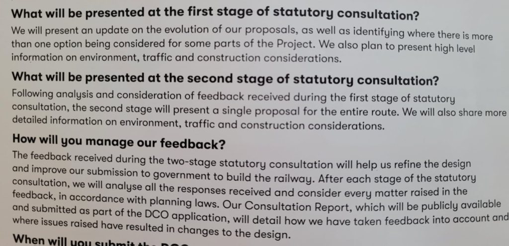
With part 1 of the SC due to start sometime “in the summer” we might expect that a full set of up to date construction maps will be published including the land take for construction, biodiversity net gain and a description of the likely impact of the construction project. All the sort of stuff that local residents need to understand about the project. However, at the “Community Conversation Event” held in Cambourne on the 10th May 2024 the following information was displayed.

So it’s just high level information on the environment, traffic and construction considerations. EWRCo. clearly have a lot of detailed design. How much will they actually share? Apparently not much.
*I have taken the base population of Cambourne as 9250 as in the EWR data, but and aware that the 2021 census figure is a little higher. It is assumed here that this is due to different definitions of what is included in the Cambourne population
14 replies on “2022 Detailed EWR Maps Again”
Great work all round. Thank you.
Political agendas, Westminster suits, old school chum clubs, keeping big donors on-side.
This is the result of a grossly unbalanced political system which allows all sorts of stuff to be voted through with minimum genuine debate, paying lip service to due process.
In all the discussions and arguments with regard to the southern route I have never seen any discussion about simply tunneling some of it on a route perhaps even slightly north of Barton and Grantchester. This would hugely reduce the environmental impact and significantly shorten the proposed southern route to the new Cambridge South station. More costly of course but perfectly feasible – consider the amount of tunneling done on the HS2 route.
… and more consistent with the objective of employing existing transport corridors, rather than concreting over virgin farmland.
Does the existence of the chalk aquifer around Cambridge complicate tunnelling here?
The maps show complete devastation of a strip of land that cuts through an area that has not seen development in millennia. It looks like a cut through the Amazon forest. Devastation to bio-diversity, local communities, farming land. This does not show how daily construction works will effect communities. This development is far more invasive than any road construction and as a local very concerning. The region needs an alternative transport policy but is this too late ?
It is not too late. The “Case for Cambridge” published alongside the Budget says “The government will work with local stakeholders, including the Greater Cambridge Partnership and the Cambridgeshire & Peterborough Combined Authority, as well as independent experts to consider long-term infrastructure requirements and potential solutions, from reservoirs to mass transit options.” It goes on to talk about the need for EWR to be integrated into the city’s transport network for the future, but it is a start that the Government has acknowledged that EWR is not a one-stop solution to Cambridgeshire’s transport needs.
One mass transit option out there is https://www.cambridge-connect.uk . It is worth looking at this website (which is a much cheaper rail alternative to Mayor James Palmer’s Cambridge Autonomous Metro that involved a great deal of tunnelling and rubber-wheeled vehicles on off-road busways). It assumes EWR will go ahead, but could instead replace it with a link from Cambourne to the East Coast Main Line. It also looks at reviving rail travel to and from Haverhill and Wisbech. Lobby CPCA and the Cambridge Delivery Group to look at Cambridge Connect’s proposals seriously and extend them to replace EWR.
Yes. I have been looking at Cambridge Connect and the Metro proposal. I like it all especially the metro as this would provide a real solution to the Cambridge congestion (only to get worse with EWR housing). I like the fact that Metro is faster and can pick up many more stops throughout Cambridgeshire and beyond. These proposals have some really detailed concepts/routes with serious comments. Can anyone explain why these two group seems like they are no longer developing their proposals ?
Colin Harris (Cambridge Connect) definitely IS still developing his proposals. He is a one-man band with a day job, though, which may explain why the website doesn’t look totally up-to-date.
The former Mayor’s CAM proposals were dropped by the current Mayor on grounds of cost. For example, he was proposing about ten times as much tunnelling as Cambridge Connect.
Here’s a very recent video made by Cambridge Connect – https://vimeo.com/945919740/bcb1602779
This just goes to amplify the devastation to the lovely surroundings that we live in and enjoy. The insistence on removing any level crossings is one of the greatest factors in creating the ugly and otherwise unnecessary heavy engineering work that will have a visual and practical impact on local life. Keep up the good work and highlight how Government (of whatever Political majority) are out of touch with the wishes of the general public.
Is there an explanation of the terms used on the map key anywhere? For example, what is the difference between “Construction & logistic sites” and “Utilities construction zone”?
Yes but on the previous blog post.
Construction sites can be returned to near original owner/ use
Utilities will remain and need access even if underground
We don’t know EWRCo.s proposal on this. If the construction land is returned to the farmers, and that is a big if, how long will it take to recover from the loss of top soil? Decades?