I hope that you all had a good break. Since our last blog post in June we have been able to read some of the responses to the EWR consultation; read the new OxCam Arc consultation and looked at the proposed update to the Greater Cambridge Local Plan. A disconnect between EWR Co.’s preferred railway alignment and the housing plan is continuing to emerge and we will illustrate this in this blog post.
If you want to make your voice heard about the OxCam Arc (of which EWR is a part) one thing you can do is to have a look at the 5 minute questionnaire put together by a group called StopTheArc – it asks some of the fundamental questions not in the official MHCLG consultation. They were kind enough to ask Cambridge Approaches to review it before publishing.
Still No Published Business Case
One of the things we do on this Cambridge Approaches blog is to ask questions about the business case for the central section of the EWR.
We know from EWR Co.’s Preferred Route Option Report published in January 2020 that the estimated total cost was £5.6Bn (having risen from £1.9Bn a year earlier) and, since we understand that this will be funded by the taxpayer, it’s not unreasonable for us to ask for the business case. For comparison, would the EWR Co. management team get very far in raising £5.6Bn on Dragon’s Den if, after working on their project since 2018, they still won’t share a business case with the people that they want to fund it? Put another way, they are taking us for granted.
For the record, the public line on the lack of business case from EWR Co. in response to our Freedom of Information request at the start of 2021, was that public servants need a safe space and that it is not normal for a business case to be published at this stage. People are sufficiently disturbed by the proposals so that they received 190,000 responses to the 2021 consultation, but it’s too early to publish the case for the project. Really?
This questioning of the business case was followed by Anthony Browne MP asking about the effect of COVID on travel patterns which will likely permanently reduce passenger numbers by 40% as people have learnt to work from home. EWR Co.’s recent video from EWR Co on the 23rd August 2021 talks about this problem (see 3:07 into the video) without any convincing resolution. Covid-19 will pass, but the technology that allows people to work from home is here to stay and employee expectations have now changed.
As EWR Co point out (video 2:36), the hope is that people will move into the area to live and work and set up businesses so it might be that this influx of people will to some extent counteract the others working from home. Indeed, the NIC report “Partnering for Prosperity” set out a target of 1.1 million additional jobs in the area by 2050 corresponding to about 2 million more people and 1 million more homes. We assume that the focus of this growth is intended to be along the EWR around the initial stations and any new ones that are added over the lifetime of the railway. (If not what is the point of the railway exactly?) The impact of this on existing residents will be higher than that of the railway alone.
The second EWR consultation ended in June 2021 and we still have a lot of unanswered questions. Looking at the consultation responses from bodies like the South Cambridgeshire District Council and the Cambridgeshire County Council, we were not the only ones with outstanding questions. You can read the Cambridge Approaches consultation response here and some others here.
In the Cambridgeshire County Council 2021 EWR consultation response we find the following:
Growth: The East West Rail Central Section should support growth and enable sustainable transport patterns to be realised from that growth. The detailed alignment of the Central Section should be considered alongside the consideration of appropriate locations for growth in the Ox-Cam Arc, and the appropriate scale of that growth. The strategy for station provision on the Central Section must be informed by the consideration of appropriate locations for growth.
This is an appeal for the route alignment of the EWR central section and its station locations to follow a co-ordinated housing plan.
South Cambridgeshire District Councils 2021 EWR consultation response says:
Significant further work is still needed to understand the localised impacts of the scheme, the options for mitigation, their effectiveness and implementation including the sequencing with wider strategic infrastructure and development.
Again, they are concerned that the railway is not aligned with the housing and economic plan for the area.
So, some of the outstanding questions centre on how the route relates to other plans for the area e.g. for economic growth, housing and local transport. Unfortunately for all concerned, the EWR Co. management team are not in a good place to answer these questions because they are being pushed by the Department for Transport to get the route defined in advance of key decisions by other bodies. This heightens the risk that EWR will not choose the right approach which will be to the detriment of its business case, local residents and potential users of the service.
Train Wreck in St. Neots
EWR Co.‘s Simon Blanchflower post consultation press release celebrated the scale of response:
The number of responses we’ve received, the breadth of information and level of detail they contain demonstrates the value of consulting with local people at an early stage, and the huge level of public interest in East West Rail.
But a strong response should not be taken as meaning respondents are in favour of what is being proposed.
A good example this and of the railway alignment not taking account of the housing plan can be found in the St. Neots Town Council Response to the EWR consultation which is, broadly, that they are furious.
We are surprised that EWR has aligned its preferred routes in close proximity to one of the largest housing developments in the East of England. None of the five corridors considered in the first phase of the consultation included this land, and the late inclusion has come as a shock to residents, housing developers and St Neots Town Council.
St Neots Town Council is opposed to the construction of these viaducts and asks EWR to urgently reconsider plans to align these routes with the eastern edge of our town.
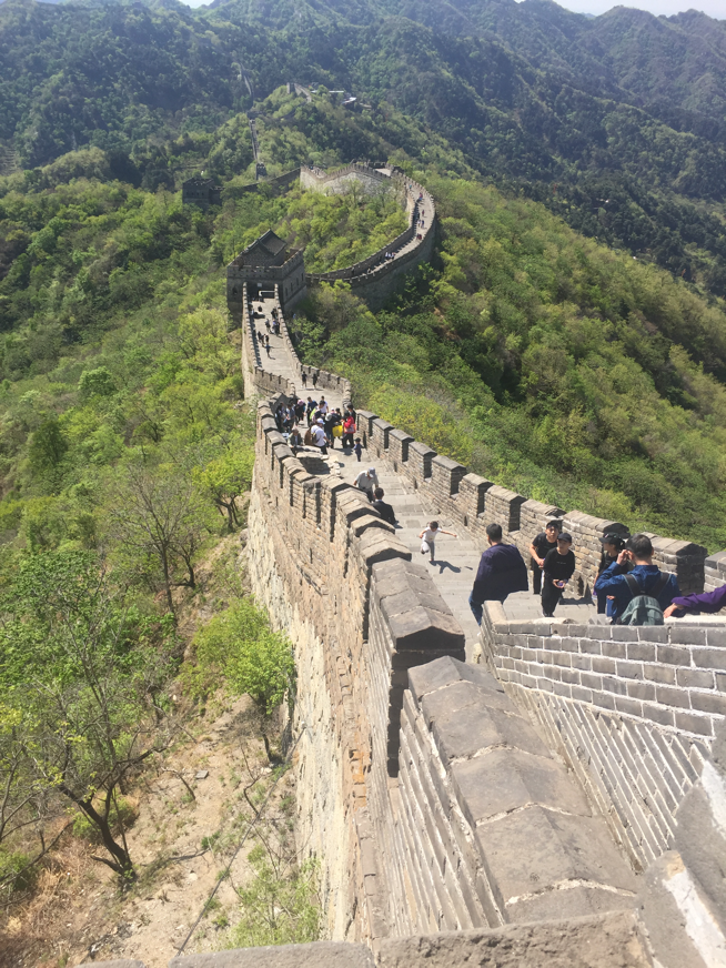
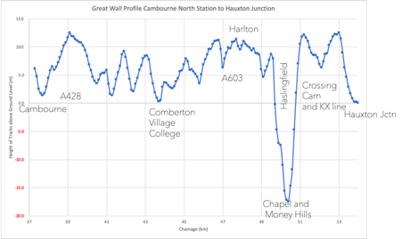
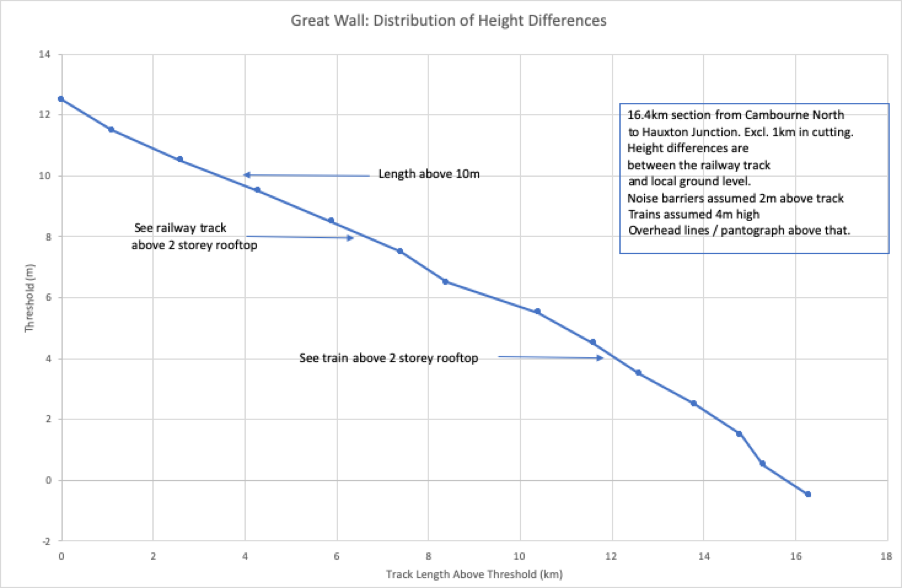
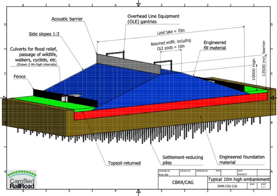
EWR are proposing 12m high viaducts through St. Neots East reminiscent of the Great Wall they have proposed between Cambourne and Hauxton. There is also no station at St. Neots, maybe that is because of the Tempsford development, but since we don’t even have a vision for the OxCam Arc Spatial framework who knows? More to the point how do EWR Co. know?
Greater Cambridge Shared Planning (GCSP) Local Plan
On the 31st August 2021 an update to the local plan was published. It is currently under consideration by councillors and will not open to public consultation until later in the year (November?). The updated plan will run to 2041 (previously it ran from 2011-2031).
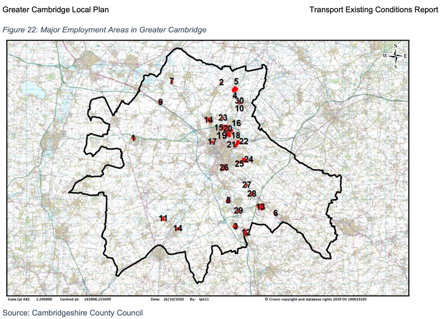
Figure 1 shows an overview map of the developments proposed.
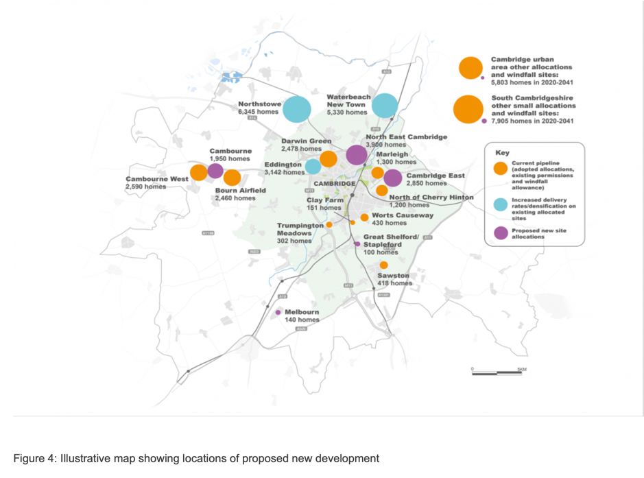
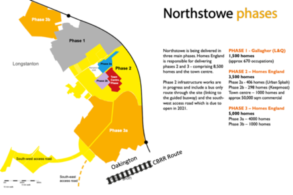
Note that no new housing development is proposed around Cambridge South Station, despite this being one of the repeated justifications for the southern approach to Cambridge for the EWR. This diminishes both the justification for the EWR southern approach route and the business case for the central section of the railway. In contrast, significant new development around the northern route proposed by CBRR is confirmed and developments in Northstowe and Waterbeach are to be accelerated together with new brown field developments to the north and east of Cambridge.
The Mythical Houses Around Cambridge South Station
The myth of significant housing growth around Cambridge South Station has been discussed in a recent letter from a local resident to local District Councillors as follows:
“…the county council’s 2019 response to EWR Co (repeated in the third bullet of paragraph 2.3 of the covering note to the draft response) said ” The ability of EWR services to … provide for the very significant planned economic and housing growth in the south of the city including at the Cambridge Biomedical Campus”. This was an odd statement in 2019, given that the county council is not the planning authority, and it was, at the time, not evident from the Local Plan what housing development the county council had in mind in saying this. It appears even odder now, given the variety of housing development options under consideration by Greater Cambridge Shared Planning (“GCSP”) – see their November 2020 development strategy options assessments and the emergence of the North East Cambridge Action Plan.
In 2019, the constituent authorities of what is now GCSP made clear a new local plan was coming and that they would be looking at all reasonable development strategies and SCDC at least has repeated this point in its response to this consultation. Notwithstanding this, what the county council said in 2019 appears to be understood as fact not just by EWR Co, but also by EWR Consortium.
Among the papers for the EWR Consortium 9 June meeting (not, in fact, discussed) is this one under the heading “realising the potential of EWR” which says (emphasis added):
Cambridge South: Cambridge South [station] will be located near to Addenbrooke’s Hospital and Cambridge Biomedical Campus – key employers and site for new homes in the south of Cambridge. Planned to open in 2025, the station will be on the Cambridge line and West Anglia Main Line, and should also sit on the East West Main Line once it opens a few years later.”
It goes on to say that “The Cambridgeshire and Peterborough Combined Authority is working on the Outline Business Case…”. It is not entirely clear what this outline business case is for and could be a historic priority of the former Mayor because the next paragraph of the document mentions the CAM.
It is possible that all these statements can be traced back to what the county council said in its 2019 response which may have served to lead others to believe that there were likely developments in the south of Cambridge. It seems important for both EWR Co and EWR Consortium to understand the true position and the county council should take responsibility for doing this.”
Now would be a good time for EWR Co and EWR Consortium to review the evidence for the southern approach and the whole business case in the light of this new local plan since the local authorities are planning no new houses around either EWR station on the southern approach in Cambridgeshire all the way out to 2041. Do MHCLG people know better that the local experts about how best to develop Cambridge?
Conflicting Plans at Highfields Caldecote
One of the consequences of the EWR route being fixed in advance of related housing plans are conflicts emerging when the housing plans do come out. The detailed costing information that came out with the last consultation indicates that the preferred route had been established in outline all the way back in mid-2019. Such conflicts can no doubt be resolved by adjustments to the railway route or knocking down houses, but they are also symptomatic of the lack of co-ordination between EWR Co. and the other planning authorities.
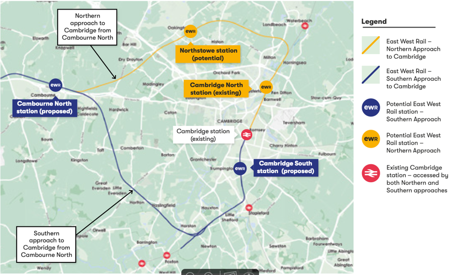
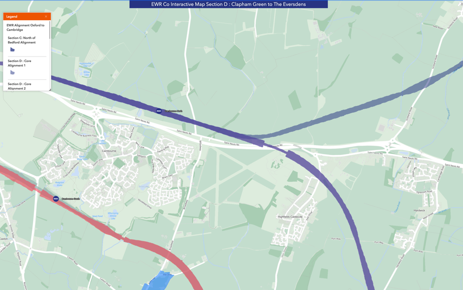
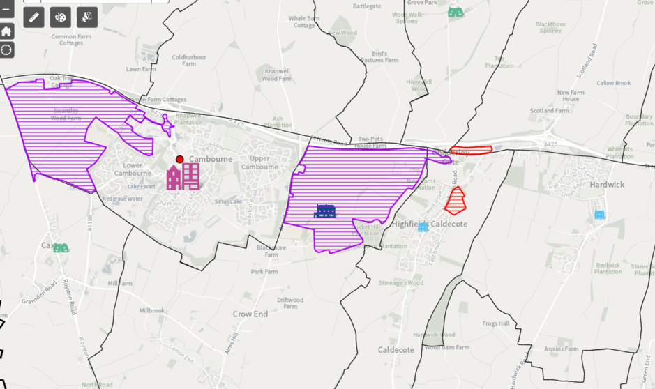
Here is another example of the issue. EWR Co’s preferred route goes through a station north of Cambourne and crosses the A428 with a long, skewed bridge just north of Highfields Caldecote (see blue route in Figure 2).
However, the updated local plan has housing across the proposed route of the railway (See Figure 3).
Rate of Housing growth
The GCSP planners are estimating that to meet the demands of the local economy (i.e. the number of new jobs they foresee over the period) we need to add 1,771 houses per year over the next 20 years leading to a total of 48,794 houses from 2011 to 2041. This is a lot less than the 271,000 houses in the National Infrastructure Commission report (NIC Report) for this end of the EWR central section up to 2050.
It has been acknowledged that the case for the EWR central section depends on housing growth. For example, this is stated in the recent EWR video referred to earlier. In fact, it depends on the transformational housing growth put forward by the NIC report. However, if this level of growth is not going to come from the local plan where could it come from?
OxCam Arc Consultation
The Ministry of Housing Communities and Local Government (MHCLG) recently launched a consultation to help them shape the vision for the OxCam Arc. In section 5.8 of this document there is a rather hard-hitting paragraph:
“5.8 In parallel to the development of the Spatial Framework, the government is also exploring options to speed up new housing and infrastructure development in the Arc to help meet its ambitions, where evidence supports it. This includes examining (and where appropriate, developing) the case for new and/or expanded settlements in the Arc, including options informed by possible East West Rail stations between Bedford and Cambridge and growth options at Cambridge itself. The government will undertake additional Arc consultations on any specific proposals for such options as appropriate. The Spatial Framework will guide the future growth of the Arc to 2050, including on the question of new housing and infrastructure and will, as part of its development, take into consideration any significant new housing and infrastructure coming forward to meet the Arc’s ambition.”
They are reserving the right to add housing developments around EWR stations including at Cambridge itself. One assumes that, coming from central government, they would not be small developments. As pointed out by the county council it would be better for the transport infrastructure to fit around the housing plan rather than vice versa. Similar problems occur with the sites for schools and hospitals if the funding and hence the location is controlled by central government.
The housing plan proposed by GCSP considers environmental aspects by choosing dense developments often on brown field sites close in to Cambridge itself. If instead the plan is to be driven by the siting of EWR stations then these benefits will be lost.
Water Supplies
I was looking at the flow of water in the Cam this morning on Stourbridge Common near to Cambridge North Station. Viewed from a footbridge, there were various pieces of vegetation and sticks on the surface, but none of them were moving at all. A recent episode of BBC Radio 4’s Costing the Earth explains why this is happening. The chalk aquifers that feed the rivers having accumulated water over a very long time are now running dry because so much water has been abstracted by the water companies to serve new houses. There is also a waste water capacity problem which leads to overflow events into the rivers. Plans to fix these problems are being studied, but are not expected to be in operation until the 2030s.
GCSP commissioned a study from Stantec on the Water Supply in late 2020 which states:
For water supply, over-abstraction of the Chalk aquifer is having a detrimental impact on environmental conditions, particularly during dry years that may become more frequent due to the impacts of climate change. None of the growth scenarios considered here offer the opportunity to mitigate these existing detrimental impacts. Even without any growth, significant environmental improvements are unlikely to be achievable until major new water supply infrastructure is operational, which is unlikely to occur before the mid-2030s. Therefore, this analysis has focussed on a “no additional detriment” neutral position. To prevent any increase in abstraction and its associated detrimental environmental impacts, mitigation measures will be necessary. All stakeholders agree this should include ambitious targets for water efficiency in new development.
If there is already a problem that won’t be fixed for 15 years why are we planning to accelerate growth in the area now?
There are also significant problems with waste water and flood risk downstream in The Fens. The campaign group Friends of the Cam has a lot more on these issues.
Discussion
In summary, the business case for the EWR central section depends on the housing growth around stations. In South Cambridgeshire the updated local plan to 2041 has accelerated housing growth in Northstowe and Waterbeach new town while Cambourne, Eddington, North East Cambridge and East Cambridge have new developments. This is not at all consistent with EWR Co.s preferred route into Cambridge south.
The level of housing growth has been objectively assessed by the planning officers to meet the needs of the area although it is not clear how the water infrastructure will cope with any more growth. It is also not clear how anyone would objectively assess housing needs – it really depends what assumptions are made. Do we want this to be a high growth area if so why? Are we trying provide more homes for London commuters? Are we trying to encourage migration into the area from other parts of the UK and abroad? Which parts of the economy are we trying to stimulate? For more in depth discussion of why the OxCam Arc is not a good idea see this article. If you would like a say try filling in this 5 minute survey.
Will MHCLG add further housing via development corporations as indicated in their consultation? Well, speaking to Eversden Parish Council recently, Bridget Smith (Leader of South Cambs. District Council) reported the housing Minister, Chris Pincher as saying that there would not be houses in addition to those that the local authorities are planning for. It would be nice to see this in writing.
We conclude that either:
(A)There is no business case for the EWR extending to Cambridge on the southern approach because it will not enable much housing growth OR
(B) Central Government need to push through large housing developments around the proposed route of EWR over and above the needs of the local economy to service additional fast economic growth in the OxCam Arc not recognised by the local planners and to serve more London commuters.
Option A is a waste of public money, option B looks like being even less popular than the railway itself and does nothing for those parts of the county that need levelling up investment.
OxCam Arc Consultations
Given the above situation, one might expect that an MHCLG consultation about the OxCam Arc vision might set out some indicative scale of development around EWR stations. It is instead phrased around prioritising various features of the plan without really setting out the core proposition. See this brief BBC South News report for some detail on the controversy around this consultation. Perhaps MHCLG are taking it a step as a time, but they are so far behind EWR Co. that their spatial framework may not be able to influence the route of EWR. MHCLG’s consultation suggests development is to be set around EWR stations no matter how poor those sites are in planning terms.
We encourage you to respond to the MHCLG consultation by October 12th. The Stop The Arc Group have some great ideas about what you might like to say here, but please also use this post to relate your response to the EWR Central Section.
The Stop The Arc Group have produced a 5 minute survey about the OxCam Arc which asks people some of the more fundamental questions about the Arc. Cambridge Approaches had some minor involvement in the development of the survey and support it.
Please do fill in the 5-minute survey here.
One of the early results of the 5 minute survey after 1500 responses is that over 90% of people would vote against the OxCam Arc if there was a referendum.